Kara geodata
Kara is a seat of a first-order administrative division; located in Togo in Africa/Lome (GMT+0) time zone. With population of 104,207 people, there are 2 cities with bigger population in this country. Compared to other cities in Togo, 75% of cities are located further ↓South; 60% of cities are located further ←West and 50% of cities have lower elevation than Kara. Note1


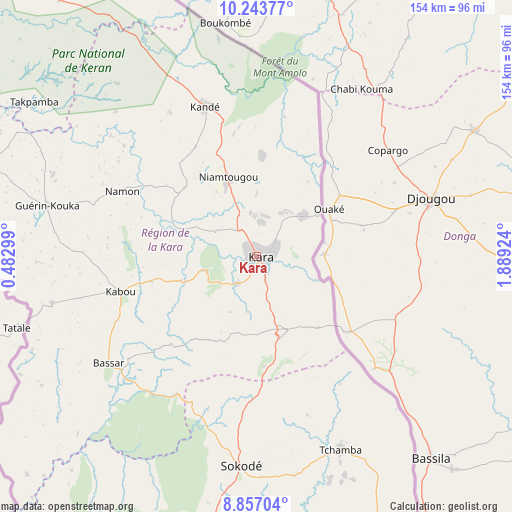
Kara GPS coordinates[2]
9° 33' 3.996" North, 1° 11' 9.996" East
| Map corner | latitude | longitude |
|---|---|---|
| Upper-left | 10.24377°, | 0.48299° |
| Center: | 9.55111°, | 1.18611° |
| Lower-right: | 8.85704°, | 1.88924° |
| Map W x H: | 154.2×154.2 km | = 95.8×95.8mi |
| max Lat: | 10.86225° ⇑25% North |
| Kara: | 9.55111° |
| min Lat: | ⇓75% South 6.12874° |
| min Long | Kara | max Long |
| 0.20762° | 1.18611° | 1.5919° |
| W 60%⇐ | ⇒40% E |
Elevation
Elevation of Kara is 291 m = 955 ft, and this is 23.9 m = 78 ft above average elevation for this country.
| Max E: |
608 m = 1995 ft | 50% |
| Kara | 291 m 955 ft | |
| Avg. | 267.1 m = 876 ft | |
Min E: |
5 m = 16 ft | 50% |
See also: Kara elevation on elevation.city.
Geographical zone
Kara is located in North Torrid zone (between Equator and Tropic of Cancer). Distance of Equator is 1062 km =659.9 mi to South.| Distance of | km | miles | from Kara |
|---|---|---|---|
| North Pole | 8945.1 | 5558.2 | to North |
| Arctic Circle | 6339.2 | 3939 | to North |
| Tropic Cancer | 1543.9 | 959.3 | to North |
| Equator | 1062 | 659.9 | to South |


Nearby cities:
15 places around Kara: (largest is in red/bold)
• Amlamé
233.9 km =145.3 mi,  187°
187°
• Atakpamé
224.4 km =139.4 mi,  181°
181°
• Badou
228.1 km =141.7 mi,  196°
196°
• Bafilo
24 km =14.9 mi,  158°
158°
• Bassar
55.5 km =34.5 mi,  232°
232°
• Dapaong
180.9 km =112.4 mi,  323°
323°
• Kandé
47.8 km =29.7 mi,  341°
341°
• Kpalimé
301 km =187 mi, 191°
• Niamtougou
25.7 km =16 mi, 339°
• Notsé
289.2 km =179.7 mi, 180°
• Pagouda
27.3 km =17 mi,  34°
34°
• Sansanné-Mango
119.2 km =74.1 mi, 318°
• Sokodé
63.4 km =39.4 mi, 185°
• Sotouboua
112 km =69.6 mi, 191°
• Tchamba
62.9 km =39.1 mi, 156°
Sources, notices
• [Note1] Compared only with cities in Togo existing in our database
• [Src1] Map data: © OpenStreetMap contributors (CC-BY-SA)
• [Src2] Other city data from geonames.org with taken over terms of usage.
• [Src3] Geographical zone / Annual Mean Temperature by Robert A. Rohde @ Wikipedia
