Bafilo geodata
Bafilo (Kara) is a populated place; located in Togo in Africa/Lome (GMT+0) time zone. With population of 22,543 people, there are 13 cities with bigger population in this country. Compared to other cities in Togo, 70% of cities are located further ↓South; 75% of cities are located further ←West and 100% of cities have lower elevation than Bafilo. Note1


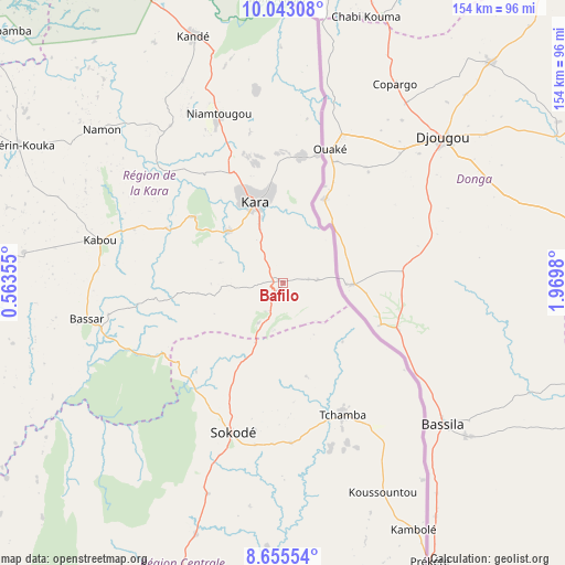
Bafilo GPS coordinates[2]
9° 21' 0" North, 1° 16' 0.012" East
| Map corner | latitude | longitude |
|---|---|---|
| Upper-left | 10.04308°, | 0.56355° |
| Center: | 9.35°, | 1.26667° |
| Lower-right: | 8.65554°, | 1.9698° |
| Map W x H: | 154.3×154.3 km | = 95.9×95.9mi |
| max Lat: | 10.86225° ⇑30% North |
| Bafilo: | 9.35° |
| min Lat: | ⇓70% South 6.12874° |
| min Long | Bafilo | max Long |
| 0.20762° | 1.26667° | 1.5919° |
| W 75%⇐ | ⇒25% E |
Elevation
Elevation of Bafilo is 608 m = 1995 ft, and this is 340.9 m = 1118 ft above average elevation for this country.
| Max E: |
608 m = 1995 ft | 0% |
| Bafilo | 608 m 1995 ft | |
| Avg. | 267.1 m = 876 ft | |
Min E: |
5 m = 16 ft | 100% |
See also: Togo elevation on elevation.city.
Geographical zone
Bafilo is located in North Torrid zone (between Equator and Tropic of Cancer). Distance of Equator is 1039.6 km =646 mi to South.| Distance of | km | miles | from Bafilo |
|---|---|---|---|
| North Pole | 8967.4 | 5572.1 | to North |
| Arctic Circle | 6361.6 | 3952.9 | to North |
| Tropic Cancer | 1566.3 | 973.3 | to North |
| Equator | 1039.6 | 646 | to South |


Nearby cities:
15 places around Bafilo: (largest is in red/bold)
• Amlamé
213.3 km =132.5 mi,  190°
190°
• Atakpamé
202.5 km =125.8 mi,  184°
184°
• Badou
209.7 km =130.3 mi,  200°
200°
• Bassar
54.3 km =33.7 mi,  258°
258°
• Dapaong
204.2 km =126.9 mi,  325°
325°
• Kandé
71.8 km =44.6 mi,  340°
340°
• Kara
24 km =14.9 mi, 338°
• Kpalimé
281.2 km =174.7 mi, 194°
• Niamtougou
49.7 km =30.9 mi, 339°
• Notsé
267.1 km =166 mi, 182°
• Pagouda
45.3 km =28.1 mi,  8°
8°
• Sansanné-Mango
142.1 km =88.3 mi,  322°
322°
• Sokodé
43.3 km =26.9 mi, 199°
• Sotouboua
92.8 km =57.7 mi, 199°
• Tchamba
38.9 km =24.2 mi,  154°
154°
Sources, notices
• [Note1] Compared only with cities in Togo existing in our database
• [Src1] Map data: © OpenStreetMap contributors (CC-BY-SA)
• [Src2] Other city data from geonames.org with taken over terms of usage.
• [Src3] Geographical zone / Annual Mean Temperature by Robert A. Rohde @ Wikipedia
