Sai Mai geodata
Sai Mai (Bangkok) is a seat of a second-order administrative division; located in Thailand in Asia/Bangkok (GMT+7) time zone. In our database, there are 331 cities with bigger population. Compared to other cities in Thailand, 65.8% of cities are located further ↑North; 53% of cities are located further →East and 99.3% of cities have higher elevation than Sai Mai. Note1


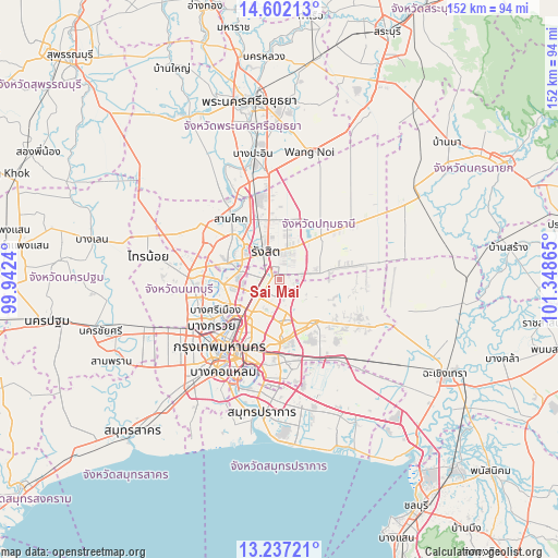
Sai Mai GPS coordinates[2]
13° 55' 14.448" North, 100° 38' 43.872" East
| Map corner | latitude | longitude |
|---|---|---|
| Upper-left | 14.60213°, | 99.9424° |
| Center: | 13.92068°, | 100.64552° |
| Lower-right: | 13.23721°, | 101.34865° |
| Map W x H: | 151.8×151.8 km | = 94.3×94.3mi |
| max Lat: | 20.43353° ⇑65.8% North |
| Sai Mai: | 13.92068° |
| min Lat: | ⇓34.2% South 5.77434° |
| min Long | Sai Mai | max Long |
| 97.93288° | 100.64552° | 105.49506° |
| W 47%⇐ | ⇒53% E |
Elevation
Elevation of Sai Mai is 4 m = 13 ft, and this is 121.5 m = 399 ft below average elevation for this country.
| Max E: |
1011 m = 3317 ft | 99.3% |
| Avg. | 125.5 m = 412 ft | |
| Sai Mai | 4 m = 13 ft | |
Min E: |
1 m = 3 ft | 0.7% |
See also: Thailand elevation on elevation.city.
Geographical zone
Sai Mai is located in North Torrid zone (between Equator and Tropic of Cancer). Distance of this Northern Tropic circle is 1058.1 km =657.5 mi to North.| Distance of | km | miles | from Sai Mai |
|---|---|---|---|
| North Pole | 8459.2 | 5256.3 | to North |
| Arctic Circle | 5853.3 | 3637.1 | to North |
| Tropic Cancer | 1058.1 | 657.5 | to North |
| Equator | 1547.8 | 961.8 | to South |


Nearby cities:
15 places around Sai Mai: (largest is in red/bold)
• Ban Bang Kadi Pathum Thani
13.5 km =8.4 mi,  310°
310°
• Ban Lam Luk Ka
15.6 km =9.7 mi,  66°
66°
• Bueng Kum
15.3 km =9.5 mi,  170°
170°
• Chatuchak
13.8 km =8.6 mi,  222°
222°
• Don Mueang
6 km =3.7 mi,  262°
262°
• Khan Na Yao
11.1 km =6.9 mi,  160°
160°
• Khlong Luang
16 km =9.9 mi,  0°
0°
• Khlong Sam Wa
13.5 km =8.4 mi,  134°
134°
• Lam Luk Ka
11.3 km =7 mi,  83°
83°
• Lat Phrao
13.7 km =8.5 mi,  197°
197°
• Min Buri
15 km =9.3 mi,  141°
141°
• Mueang Nonthaburi
15.6 km =9.7 mi,  244°
244°
• Pak Kret
15.9 km =9.9 mi,  266°
266°
• Thanyaburi
14.7 km =9.1 mi,  40°
40°
• Wang Thonglang
15.5 km =9.6 mi,  193°
193°
Sources, notices
• [Note1] Compared only with cities in Thailand existing in our database
• [Src1] Map data: © OpenStreetMap contributors (CC-BY-SA)
• [Src2] Other city data from geonames.org with taken over terms of usage.
• [Src3] Geographical zone / Annual Mean Temperature by Robert A. Rohde @ Wikipedia
