Rawai geodata
Rawai (Phuket) is a populated place; located in Thailand in Asia/Bangkok (GMT+7) time zone. With population of 13,623 people, there are 241 cities with bigger population in this country. Compared to other cities in Thailand, 91.4% of cities are located further ↑North; 98.4% of cities are located further →East and 80.8% of cities have higher elevation than Rawai. Note1


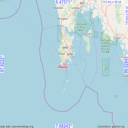
Rawai GPS coordinates[2]
7° 46' 46.74" North, 98° 19' 31.152" East
| Map corner | latitude | longitude |
|---|---|---|
| Upper-left | 8.47571°, | 97.6222° |
| Center: | 7.77965°, | 98.32532° |
| Lower-right: | 7.08243°, | 99.02845° |
| Map W x H: | 154.9×154.9 km | = 96.3×96.3mi |
| max Lat: | 20.43353° ⇑91.4% North |
| Rawai: | 7.77965° |
| min Lat: | ⇓8.6% South 5.77434° |
| min Long | Rawai | max Long |
| 97.93288° | 98.32532° | 105.49506° |
| W 1.6%⇐ | ⇒98.4% E |
Elevation
Elevation of Rawai is 12 m = 39 ft, and this is 113.5 m = 372 ft below average elevation for this country.
| Max E: |
1011 m = 3317 ft | 80.8% |
| Avg. | 125.5 m = 412 ft | |
| Rawai | 12 m = 39 ft | |
Min E: |
1 m = 3 ft | 19.2% |
See also: Thailand elevation on elevation.city.
Geographical zone
Rawai is located in North Torrid zone (between Equator and Tropic of Cancer). Distance of Equator is 865 km =537.5 mi to South.| Distance of | km | miles | from Rawai |
|---|---|---|---|
| North Pole | 9142 | 5680.6 | to North |
| Arctic Circle | 6536.2 | 4061.4 | to North |
| Tropic Cancer | 1740.9 | 1081.7 | to North |
| Equator | 865 | 537.5 | to South |


Nearby cities:
15 places around Rawai: (largest is in red/bold)
• Ban Chalong
7.4 km =4.6 mi,  11°
11°
• Ban Karon
8.1 km =5 mi,  338°
338°
• Ban Kata
5 km =3.1 mi, 336°
• Ban Ko Kaeo
19.1 km =11.9 mi,  24°
24°
• Ban Phru Nai
35 km =21.7 mi,  56°
56°
• Ban Ratsada
16.8 km =10.4 mi,  30°
30°
• Ban Talat Nua
13.5 km =8.4 mi, 29°
• Ban Talat Yai
14.3 km =8.9 mi,  35°
35°
• Kathu
15.4 km =9.6 mi,  3°
3°
• Mueang Phuket
10.3 km =6.4 mi, 24°
• Nai Harn
2.1 km =1.3 mi,  266°
266°
• Patong
13.3 km =8.3 mi,  346°
346°
• Phuket
14.7 km =9.1 mi, 33°
• Thalang
28 km =17.4 mi, 1°
• Wichit
13.9 km =8.6 mi, 28°
Sources, notices
• [Note1] Compared only with cities in Thailand existing in our database
• [Src1] Map data: © OpenStreetMap contributors (CC-BY-SA)
• [Src2] Other city data from geonames.org with taken over terms of usage.
• [Src3] Geographical zone / Annual Mean Temperature by Robert A. Rohde @ Wikipedia
