Mae Wang geodata
Mae Wang (Chiang Mai) is a seat of a second-order administrative division; located in Thailand in Asia/Bangkok (GMT+7) time zone. In our database, there are 331 cities with bigger population. Compared to other cities in Thailand, 93.1% of cities are located further ↓South; 94.1% of cities are located further →East and 93% of cities have lower elevation than Mae Wang. Note1


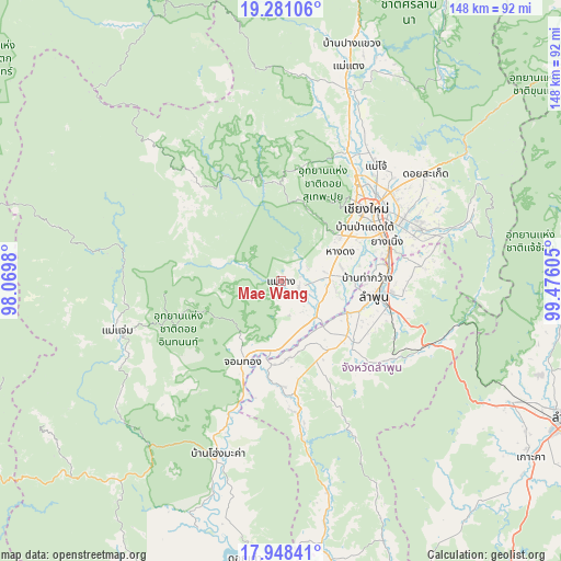
Mae Wang GPS coordinates[2]
18° 36' 57.744" North, 98° 46' 22.512" East
| Map corner | latitude | longitude |
|---|---|---|
| Upper-left | 19.28106°, | 98.0698° |
| Center: | 18.61604°, | 98.77292° |
| Lower-right: | 17.94841°, | 99.47605° |
| Map W x H: | 148.2×148.2 km | = 92.1×92.1mi |
| max Lat: | 20.43353° ⇑6.9% North |
| Mae Wang: | 18.61604° |
| min Lat: | ⇓93.1% South 5.77434° |
| min Long | Mae Wang | max Long |
| 97.93288° | 98.77292° | 105.49506° |
| W 5.9%⇐ | ⇒94.1% E |
Elevation
Elevation of Mae Wang is 335 m = 1099 ft, and this is 209.5 m = 687 ft above average elevation for this country.
| Max E: |
1011 m = 3317 ft | 7% |
| Mae Wang | 335 m 1099 ft | |
| Avg. | 125.5 m = 412 ft | |
Min E: |
1 m = 3 ft | 93% |
See also: Thailand elevation on elevation.city.
Geographical zone
Mae Wang is located in North Torrid zone (between Equator and Tropic of Cancer). Distance of this Northern Tropic circle is 536 km =333.1 mi to North.| Distance of | km | miles | from Mae Wang |
|---|---|---|---|
| North Pole | 7937.2 | 4931.9 | to North |
| Arctic Circle | 5331.3 | 3312.7 | to North |
| Tropic Cancer | 536 | 333.1 | to North |
| Equator | 2069.9 | 1286.2 | to South |


Nearby cities:
15 places around Mae Wang: (largest is in red/bold)
• Ban Hong
32.1 km =19.9 mi,  171°
171°
• Ban Thi
36.3 km =22.6 mi,  87°
87°
• Chiang Mai
29.5 km =18.3 mi,  49°
49°
• Chom Thong
24.4 km =15.2 mi,  205°
205°
• Doi Lo
17.2 km =10.7 mi,  178°
178°
• Hang Dong
17.3 km =10.7 mi,  62°
62°
• Lamphun
25 km =15.5 mi,  99°
99°
• Mae Tha
42.2 km =26.2 mi,  113°
113°
• Pa Sang
20.2 km =12.6 mi,  119°
119°
• Samoeng
26.1 km =16.2 mi,  350°
350°
• San Kamphaeng
39.2 km =24.4 mi,  68°
68°
• San Pa Tong
13 km =8.1 mi,  83°
83°
• San Sai
38.5 km =23.9 mi, 48°
• Saraphi
29.7 km =18.5 mi, 68°
• Wiang Nong Long
21.9 km =13.6 mi,  186°
186°
Sources, notices
• [Note1] Compared only with cities in Thailand existing in our database
• [Src1] Map data: © OpenStreetMap contributors (CC-BY-SA)
• [Src2] Other city data from geonames.org with taken over terms of usage.
• [Src3] Geographical zone / Annual Mean Temperature by Robert A. Rohde @ Wikipedia
