Lamphun geodata
Lamphun is a seat of a first-order administrative division; located in Thailand in Asia/Bangkok (GMT+7) time zone. With population of 43,196 people, there are 69 cities with bigger population in this country. Compared to other cities in Thailand, 92.9% of cities are located further ↓South; 91.9% of cities are located further →East and 91.3% of cities have lower elevation than Lamphun. Note1


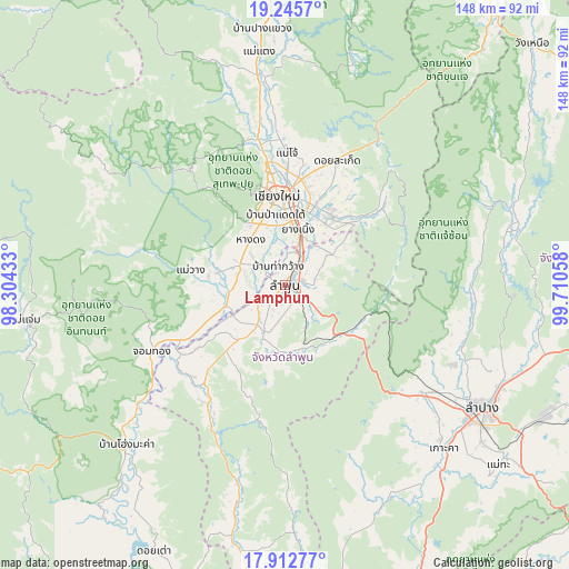
Lamphun GPS coordinates[2]
18° 34' 49.944" North, 99° 0' 26.82" East
| Map corner | latitude | longitude |
|---|---|---|
| Upper-left | 19.2457°, | 98.30433° |
| Center: | 18.58054°, | 99.00745° |
| Lower-right: | 17.91277°, | 99.71058° |
| Map W x H: | 148.2×148.2 km | = 92.1×92.1mi |
| max Lat: | 20.43353° ⇑7.1% North |
| Lamphun: | 18.58054° |
| min Lat: | ⇓92.9% South 5.77434° |
| min Long | Lamphun | max Long |
| 97.93288° | 99.00745° | 105.49506° |
| W 8.1%⇐ | ⇒91.9% E |
Elevation
Elevation of Lamphun is 296 m = 971 ft, and this is 170.5 m = 559 ft above average elevation for this country.
| Max E: |
1011 m = 3317 ft | 8.7% |
| Lamphun | 296 m 971 ft | |
| Avg. | 125.5 m = 412 ft | |
Min E: |
1 m = 3 ft | 91.3% |
See also: Lamphun elevation on elevation.city.
Geographical zone
Lamphun is located in North Torrid zone (between Equator and Tropic of Cancer). Distance of this Northern Tropic circle is 540 km =335.5 mi to North.| Distance of | km | miles | from Lamphun |
|---|---|---|---|
| North Pole | 7941.1 | 4934.4 | to North |
| Arctic Circle | 5335.2 | 3315.1 | to North |
| Tropic Cancer | 540 | 335.5 | to North |
| Equator | 2066 | 1283.8 | to South |


Nearby cities:
15 places around Lamphun: (largest is in red/bold)
• Ban Hong
34.1 km =21.2 mi,  215°
215°
• Ban Thi
12.8 km =8 mi,  63°
63°
• Chiang Mai
23.5 km =14.6 mi,  354°
354°
• Chom Thong
39.5 km =24.5 mi,  242°
242°
• Doi Lo
27.6 km =17.1 mi, 241°
• Hang Dong
15 km =9.3 mi,  321°
321°
• Mae On
33.5 km =20.8 mi,  49°
49°
• Mae Tha
19 km =11.8 mi,  132°
132°
• Mae Wang
25 km =15.5 mi,  279°
279°
• Pa Sang
9.4 km =5.8 mi,  229°
229°
• San Kamphaeng
21.8 km =13.5 mi,  32°
32°
• San Pa Tong
12.9 km =8 mi,  294°
294°
• San Sai
30 km =18.6 mi,  7°
7°
• Saraphi
15.1 km =9.4 mi, 11°
• Wiang Nong Long
32.5 km =20.2 mi, 236°
Sources, notices
• [Note1] Compared only with cities in Thailand existing in our database
• [Src1] Map data: © OpenStreetMap contributors (CC-BY-SA)
• [Src2] Other city data from geonames.org with taken over terms of usage.
• [Src3] Geographical zone / Annual Mean Temperature by Robert A. Rohde @ Wikipedia
