Chiang Mai geodata
Chiang Mai is a seat of a first-order administrative division; located in Thailand in Asia/Bangkok (GMT+7) time zone. With population of 200,952 people, there are 6 cities with bigger population in this country. Compared to other cities in Thailand, 94.5% of cities are located further ↓South; 92.1% of cities are located further →East and 92.3% of cities have lower elevation than Chiang Mai. Note1


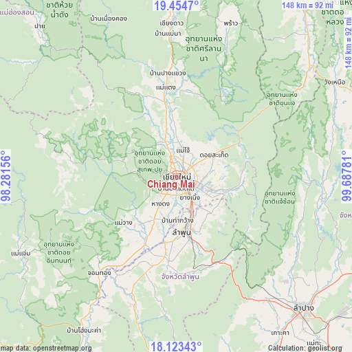
Chiang Mai GPS coordinates[2]
18° 47' 25.368" North, 98° 59' 4.848" East
| Map corner | latitude | longitude |
|---|---|---|
| Upper-left | 19.4547°, | 98.28156° |
| Center: | 18.79038°, | 98.98468° |
| Lower-right: | 18.12343°, | 99.68781° |
| Map W x H: | 148×148 km | = 92×92mi |
| max Lat: | 20.43353° ⇑5.5% North |
| Chiang Mai: | 18.79038° |
| min Lat: | ⇓94.5% South 5.77434° |
| min Long | Chiang Mai | max Long |
| 97.93288° | 98.98468° | 105.49506° |
| W 7.9%⇐ | ⇒92.1% E |
Elevation
Elevation of Chiang Mai is 313 m = 1027 ft, and this is 187.5 m = 615 ft above average elevation for this country.
| Max E: |
1011 m = 3317 ft | 7.7% |
| Chiang Mai | 313 m 1027 ft | |
| Avg. | 125.5 m = 412 ft | |
Min E: |
1 m = 3 ft | 92.3% |
See also: Chiang Mai elevation on elevation.city.
Geographical zone
Chiang Mai is located in North Torrid zone (between Equator and Tropic of Cancer). Distance of this Northern Tropic circle is 516.6 km =321 mi to North.| Distance of | km | miles | from Chiang Mai |
|---|---|---|---|
| North Pole | 7917.8 | 4919.9 | to North |
| Arctic Circle | 5311.9 | 3300.7 | to North |
| Tropic Cancer | 516.6 | 321 | to North |
| Equator | 2089.3 | 1298.2 | to South |


Nearby cities:
15 places around Chiang Mai: (largest is in red/bold)
• Ban Thi
22.4 km =13.9 mi,  141°
141°
• Doi Lo
42.6 km =26.5 mi,  210°
210°
• Hang Dong
13.4 km =8.3 mi, 210°
• Lamphun
23.5 km =14.6 mi,  174°
174°
• Mae On
27.8 km =17.3 mi,  93°
93°
• Mae Taeng
36.6 km =22.7 mi,  352°
352°
• Mae Tha
39.8 km =24.7 mi,  155°
155°
• Mae Wang
29.5 km =18.3 mi,  229°
229°
• Pa Sang
29.8 km =18.5 mi,  189°
189°
• Samoeng
27.3 km =17 mi,  283°
283°
• San Kamphaeng
15.1 km =9.4 mi,  109°
109°
• San Pa Tong
20.3 km =12.6 mi, 207°
• San Sai
9 km =5.6 mi,  44°
44°
• Saraphi
10 km =6.2 mi,  147°
147°
• Wiang Nong Long
48 km =29.8 mi, 211°
Sources, notices
• [Note1] Compared only with cities in Thailand existing in our database
• [Src1] Map data: © OpenStreetMap contributors (CC-BY-SA)
• [Src2] Other city data from geonames.org with taken over terms of usage.
• [Src3] Geographical zone / Annual Mean Temperature by Robert A. Rohde @ Wikipedia
