San Kamphaeng geodata
San Kamphaeng (Chiang Mai) is a seat of a second-order administrative division; located in Thailand in Asia/Bangkok (GMT+7) time zone. With population of 32,950 people, there are 101 cities with bigger population in this country. Compared to other cities in Thailand, 94% of cities are located further ↓South; 90.2% of cities are located further →East and 92.1% of cities have lower elevation than San Kamphaeng. Note1


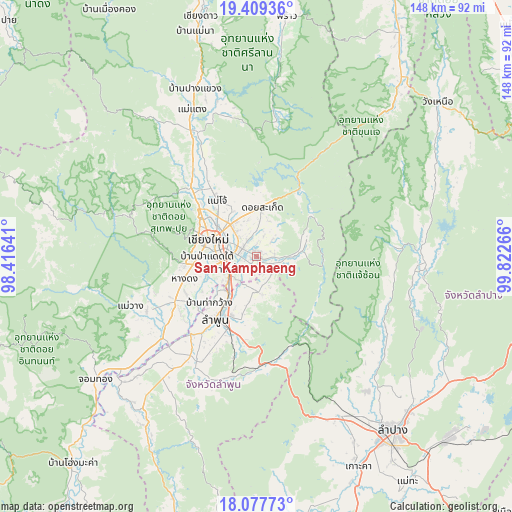
San Kamphaeng GPS coordinates[2]
18° 44' 41.496" North, 99° 7' 10.308" East
| Map corner | latitude | longitude |
|---|---|---|
| Upper-left | 19.40936°, | 98.41641° |
| Center: | 18.74486°, | 99.11953° |
| Lower-right: | 18.07773°, | 99.82266° |
| Map W x H: | 148.1×148.1 km | = 92×92mi |
| max Lat: | 20.43353° ⇑6% North |
| San Kamphaeng: | 18.74486° |
| min Lat: | ⇓94% South 5.77434° |
| min Long | San Kamphaeng | max Long |
| 97.93288° | 99.11953° | 105.49506° |
| W 9.8%⇐ | ⇒90.2% E |
Elevation
Elevation of San Kamphaeng is 311 m = 1020 ft, and this is 185.5 m = 609 ft above average elevation for this country.
| Max E: |
1011 m = 3317 ft | 7.9% |
| San Kamphaeng | 311 m 1020 ft | |
| Avg. | 125.5 m = 412 ft | |
Min E: |
1 m = 3 ft | 92.1% |
See also: Thailand elevation on elevation.city.
Geographical zone
San Kamphaeng is located in North Torrid zone (between Equator and Tropic of Cancer). Distance of this Northern Tropic circle is 521.7 km =324.2 mi to North.| Distance of | km | miles | from San Kamphaeng |
|---|---|---|---|
| North Pole | 7922.8 | 4923 | to North |
| Arctic Circle | 5316.9 | 3303.8 | to North |
| Tropic Cancer | 521.7 | 324.2 | to North |
| Equator | 2084.2 | 1295.1 | to South |


Nearby cities:
15 places around San Kamphaeng: (largest is in red/bold)
• Ban Thi
12.6 km =7.8 mi,  181°
181°
• Chae Hom
46.3 km =28.8 mi,  94°
94°
• Chiang Mai
15.1 km =9.4 mi,  289°
289°
• Hang Dong
22 km =13.7 mi,  253°
253°
• Lamphun
21.8 km =13.5 mi,  212°
212°
• Mae On
14 km =8.7 mi,  75°
75°
• Mae Taeng
45.4 km =28.2 mi,  335°
335°
• Mae Tha
31.2 km =19.4 mi, 175°
• Mae Wang
39.2 km =24.4 mi, 248°
• Mueang Pan
40.4 km =25.1 mi, 86°
• Pa Sang
30.8 km =19.1 mi,  217°
217°
• Samoeng
42.3 km =26.3 mi, 285°
• San Pa Tong
26.9 km =16.7 mi,  241°
241°
• San Sai
13.9 km =8.6 mi,  325°
325°
• Saraphi
9.5 km =5.9 mi, 248°
Sources, notices
• [Note1] Compared only with cities in Thailand existing in our database
• [Src1] Map data: © OpenStreetMap contributors (CC-BY-SA)
• [Src2] Other city data from geonames.org with taken over terms of usage.
• [Src3] Geographical zone / Annual Mean Temperature by Robert A. Rohde @ Wikipedia
