Tha Song Yang geodata
Tha Song Yang (Tak) is a seat of a second-order administrative division; located in Thailand in Asia/Bangkok (GMT+7) time zone. In our database, there are 331 cities with bigger population. Compared to other cities in Thailand, 81% of cities are located further ↓South; 99.4% of cities are located further →East and 57.4% of cities have lower elevation than Tha Song Yang. Note1


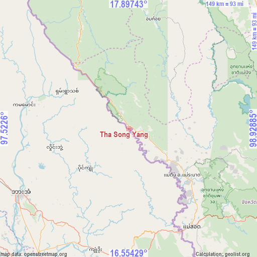
Tha Song Yang GPS coordinates[2]
17° 13' 37.488" North, 98° 13' 32.592" East
| Map corner | latitude | longitude |
|---|---|---|
| Upper-left | 17.89743°, | 97.5226° |
| Center: | 17.22708°, | 98.22572° |
| Lower-right: | 16.55429°, | 98.92885° |
| Map W x H: | 149.3×149.3 km | = 92.8×92.8mi |
| max Lat: | 20.43353° ⇑19% North |
| Tha Song Yang: | 17.22708° |
| min Lat: | ⇓81% South 5.77434° |
| min Long | Tha Song Yang | max Long |
| 97.93288° | 98.22572° | 105.49506° |
| W 0.6%⇐ | ⇒99.4% E |
Elevation
Elevation of Tha Song Yang is 142 m = 466 ft, and this is 16.5 m = 54 ft above average elevation for this country.
| Max E: |
1011 m = 3317 ft | 42.6% |
| Tha Song Yang | 142 m 466 ft | |
| Avg. | 125.5 m = 412 ft | |
Min E: |
1 m = 3 ft | 57.4% |
See also: Thailand elevation on elevation.city.
Geographical zone
Tha Song Yang is located in North Torrid zone (between Equator and Tropic of Cancer). Distance of this Northern Tropic circle is 690.4 km =429 mi to North.| Distance of | km | miles | from Tha Song Yang |
|---|---|---|---|
| North Pole | 8091.6 | 5027.9 | to North |
| Arctic Circle | 5485.7 | 3408.7 | to North |
| Tropic Cancer | 690.4 | 429 | to North |
| Equator | 1915.5 | 1190.2 | to South |


Nearby cities:
15 places around Tha Song Yang: (largest is in red/bold)
• Ban Huai I Huak
96.8 km =60.1 mi,  347°
347°
• Ban Pa Pae
118.9 km =73.9 mi, 351°
• Ban Tak
93.2 km =57.9 mi,  102°
102°
• Doi Tao
94.2 km =58.5 mi,  31°
31°
• Hot
114.9 km =71.4 mi,  20°
20°
• Li
100.1 km =62.2 mi,  50°
50°
• Mae Phrik
97.4 km =60.5 mi,  75°
75°
• Mae Ramat
41.1 km =25.5 mi,  131°
131°
• Mae Sot
67.3 km =41.8 mi,  147°
147°
• Om Koi
65.4 km =40.6 mi,  12°
12°
• Phop Phra
105.9 km =65.8 mi, 152°
• Sam Ngao
84.6 km =52.6 mi,  88°
88°
• Sop Moei
87.4 km =54.3 mi,  339°
339°
• Tak
103.9 km =64.6 mi,  112°
112°
• Thoen
113.5 km =70.5 mi,  67°
67°
Sources, notices
• [Note1] Compared only with cities in Thailand existing in our database
• [Src1] Map data: © OpenStreetMap contributors (CC-BY-SA)
• [Src2] Other city data from geonames.org with taken over terms of usage.
• [Src3] Geographical zone / Annual Mean Temperature by Robert A. Rohde @ Wikipedia
