Tak geodata
Tak is a seat of a first-order administrative division; located in Thailand in Asia/Bangkok (GMT+7) time zone. With population of 24,149 people, there are 133 cities with bigger population in this country. Compared to other cities in Thailand, 76.9% of cities are located further ↓South; 90.1% of cities are located further →East and 51.5% of cities have lower elevation than Tak. Note1


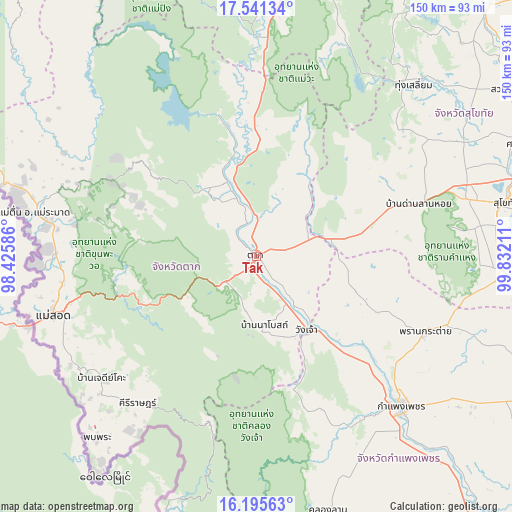
Tak GPS coordinates[2]
16° 52' 10.848" North, 99° 7' 44.328" East
| Map corner | latitude | longitude |
|---|---|---|
| Upper-left | 17.54134°, | 98.42586° |
| Center: | 16.86968°, | 99.12898° |
| Lower-right: | 16.19563°, | 99.83211° |
| Map W x H: | 149.6×149.6 km | = 93×93mi |
| max Lat: | 20.43353° ⇑23.1% North |
| Tak: | 16.86968° |
| min Lat: | ⇓76.9% South 5.77434° |
| min Long | Tak | max Long |
| 97.93288° | 99.12898° | 105.49506° |
| W 9.9%⇐ | ⇒90.1% E |
Elevation
Elevation of Tak is 113 m = 371 ft, and this is 12.5 m = 41 ft below average elevation for this country.
| Max E: |
1011 m = 3317 ft | 48.5% |
| Avg. | 125.5 m = 412 ft | |
| Tak | 113 m = 371 ft | |
Min E: |
1 m = 3 ft | 51.5% |
See also: Thailand elevation on elevation.city.
Geographical zone
Tak is located in North Torrid zone (between Equator and Tropic of Cancer). Distance of this Northern Tropic circle is 730.2 km =453.7 mi to North.| Distance of | km | miles | from Tak |
|---|---|---|---|
| North Pole | 8131.3 | 5052.6 | to North |
| Arctic Circle | 5525.4 | 3433.3 | to North |
| Tropic Cancer | 730.2 | 453.7 | to North |
| Equator | 1875.7 | 1165.5 | to South |


Nearby cities:
15 places around Tak: (largest is in red/bold)
• Ban Dan Lan Hoi
49.8 km =30.9 mi,  72°
72°
• Ban Na
66.3 km =41.2 mi,  75°
75°
• Ban Tak
20 km =12.4 mi,  345°
345°
• Kamphaeng Phet
59.9 km =37.2 mi,  135°
135°
• Khiri Mat
71.5 km =44.4 mi,  93°
93°
• Kosamphi Nakhon
35.4 km =22 mi, 138°
• Mae Phrik
64.2 km =39.9 mi,  358°
358°
• Mae Ramat
66.4 km =41.3 mi,  281°
281°
• Mae Sot
62.2 km =38.6 mi,  254°
254°
• Phop Phra
71.4 km =44.4 mi,  220°
220°
• Phran Kratai
54 km =33.6 mi,  114°
114°
• Sam Ngao
43.1 km =26.8 mi,  344°
344°
• Sukhothai
75.4 km =46.9 mi, 78°
• Thung Saliam
68 km =42.3 mi,  42°
42°
• Wang Chao
26.3 km =16.3 mi,  145°
145°
Sources, notices
• [Note1] Compared only with cities in Thailand existing in our database
• [Src1] Map data: © OpenStreetMap contributors (CC-BY-SA)
• [Src2] Other city data from geonames.org with taken over terms of usage.
• [Src3] Geographical zone / Annual Mean Temperature by Robert A. Rohde @ Wikipedia
