Thoen geodata
Thoen (Lampang) is a seat of a second-order administrative division; located in Thailand in Asia/Bangkok (GMT+7) time zone. With population of 18,459 people, there are 172 cities with bigger population in this country. Compared to other cities in Thailand, 85.1% of cities are located further ↓South; 88.7% of cities are located further →East and 70.6% of cities have lower elevation than Thoen. Note1


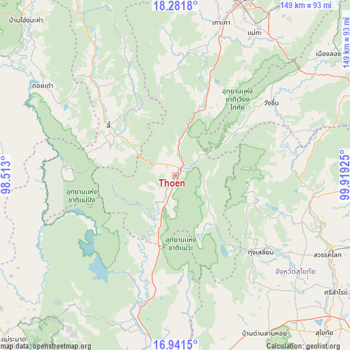
Thoen GPS coordinates[2]
17° 36' 46.404" North, 99° 12' 58.032" East
| Map corner | latitude | longitude |
|---|---|---|
| Upper-left | 18.2818°, | 98.513° |
| Center: | 17.61289°, | 99.21612° |
| Lower-right: | 16.9415°, | 99.91925° |
| Map W x H: | 149×149 km | = 92.6×92.6mi |
| max Lat: | 20.43353° ⇑14.9% North |
| Thoen: | 17.61289° |
| min Lat: | ⇓85.1% South 5.77434° |
| min Long | Thoen | max Long |
| 97.93288° | 99.21612° | 105.49506° |
| W 11.3%⇐ | ⇒88.7% E |
Elevation
Elevation of Thoen is 170 m = 558 ft, and this is 44.5 m = 146 ft above average elevation for this country.
| Max E: |
1011 m = 3317 ft | 29.4% |
| Thoen | 170 m 558 ft | |
| Avg. | 125.5 m = 412 ft | |
Min E: |
1 m = 3 ft | 70.6% |
See also: Thailand elevation on elevation.city.
Geographical zone
Thoen is located in North Torrid zone (between Equator and Tropic of Cancer). Distance of this Northern Tropic circle is 647.5 km =402.3 mi to North.| Distance of | km | miles | from Thoen |
|---|---|---|---|
| North Pole | 8048.7 | 5001.2 | to North |
| Arctic Circle | 5442.8 | 3382 | to North |
| Tropic Cancer | 647.5 | 402.3 | to North |
| Equator | 1958.4 | 1216.9 | to South |


Nearby cities:
15 places around Thoen: (largest is in red/bold)
• Ban Dan Lan Hoi
77.4 km =48.1 mi,  150°
150°
• Ban Tak
64.9 km =40.3 mi,  192°
192°
• Doi Tao
67.8 km =42.1 mi,  303°
303°
• Ko Kha
67.1 km =41.7 mi,  16°
16°
• Li
35.1 km =21.8 mi,  306°
306°
• Mae Phrik
21.4 km =13.3 mi,  210°
210°
• Mae Tha
66 km =41 mi,  28°
28°
• Sam Ngao
45.9 km =28.5 mi, 206°
• Sawankhalok
73.2 km =45.5 mi,  116°
116°
• Si Satchanalai
58.6 km =36.4 mi,  100°
100°
• Soem Ngam
50.4 km =31.3 mi,  3°
3°
• Sop Prap
32.4 km =20.1 mi, 23°
• Thung Hua Chang
47.7 km =29.6 mi,  335°
335°
• Thung Saliam
48.9 km =30.4 mi,  131°
131°
• Wang Chin
51.3 km =31.9 mi,  54°
54°
Sources, notices
• [Note1] Compared only with cities in Thailand existing in our database
• [Src1] Map data: © OpenStreetMap contributors (CC-BY-SA)
• [Src2] Other city data from geonames.org with taken over terms of usage.
• [Src3] Geographical zone / Annual Mean Temperature by Robert A. Rohde @ Wikipedia
