Huai Khot geodata
Huai Khot (Uthai Thani) is a seat of a second-order administrative division; located in Thailand in Asia/Bangkok (GMT+7) time zone. With population of 5,940 people, there are 305 cities with bigger population in this country. Compared to other cities in Thailand, 54.6% of cities are located further ↓South; 82.8% of cities are located further →East and 50.7% of cities have lower elevation than Huai Khot. Note1


Huai Khot GPS coordinates[2]
15° 17' 27.42" North, 99° 36' 59.796" East
| Map corner | latitude | longitude |
|---|---|---|
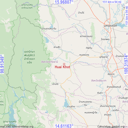
| Upper-left | 15.96807°, | 98.91349° |
| Center: | 15.29095°, | 99.61661° |
| Lower-right: | 14.61163°, | 100.31974° |
| Map W x H: | 150.8×150.8 km | = 93.7×93.7mi |
| max Lat: | 20.43353° ⇑45.4% North |
| Huai Khot: | 15.29095° |
| min Lat: | ⇓54.6% South 5.77434° |
| min Long | Huai Khot | max Long |
| 97.93288° | 99.61661° | 105.49506° |
| W 17.2%⇐ | ⇒82.8% E |
Elevation
Elevation of Huai Khot is 106 m = 348 ft, and this is 19.5 m = 64 ft below average elevation for this country.
| Max E: |
1011 m = 3317 ft | 49.3% |
| Avg. | 125.5 m = 412 ft | |
| Huai Khot | 106 m = 348 ft | |
Min E: |
1 m = 3 ft | 50.7% |
See also: Thailand elevation on elevation.city.
Geographical zone
Huai Khot is located in North Torrid zone (between Equator and Tropic of Cancer). Distance of this Northern Tropic circle is 905.7 km =562.8 mi to North.| Distance of | km | miles | from Huai Khot |
|---|---|---|---|
| North Pole | 8306.9 | 5161.7 | to North |
| Arctic Circle | 5701 | 3542.4 | to North |
| Tropic Cancer | 905.7 | 562.8 | to North |
| Equator | 1700.2 | 1056.5 | to South |


Nearby cities:
15 places around Huai Khot: (largest is in red/bold)
• Ban Rai
25.2 km =15.7 mi,  204°
204°
• Chum Ta Bong
38.5 km =23.9 mi,  349°
349°
• Dan Chang
50.7 km =31.5 mi,  170°
170°
• Lan Sak
18.5 km =11.5 mi, 346°
• Lat Yao
54.4 km =33.8 mi,  19°
19°
• Mae Poen
43.7 km =27.2 mi,  338°
338°
• Manorom
50 km =31.1 mi,  87°
87°
• Noen Kham
51.3 km =31.9 mi,  137°
137°
• Nong Chang
26.6 km =16.5 mi,  65°
65°
• Nong Kha Yang
34.5 km =21.4 mi,  76°
76°
• Nong Mamong
26.8 km =16.7 mi, 93°
• Sawang Arom
41.8 km =26 mi,  38°
38°
• Thap Than
35 km =21.7 mi,  57°
57°
• Uthai Thani
44.8 km =27.8 mi, 77°
• Wat Sing
45.6 km =28.3 mi, 94°
Sources, notices
• [Note1] Compared only with cities in Thailand existing in our database
• [Src1] Map data: © OpenStreetMap contributors (CC-BY-SA)
• [Src2] Other city data from geonames.org with taken over terms of usage.
• [Src3] Geographical zone / Annual Mean Temperature by Robert A. Rohde @ Wikipedia
