Lat Yao geodata
Lat Yao (Nakhon Sawan) is a seat of a second-order administrative division; located in Thailand in Asia/Bangkok (GMT+7) time zone. With population of 17,506 people, there are 180 cities with bigger population in this country. Compared to other cities in Thailand, 61.9% of cities are located further ↓South; 79.4% of cities are located further →East and 54% of cities have higher elevation than Lat Yao. Note1


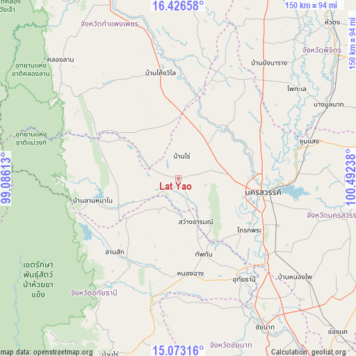
Lat Yao GPS coordinates[2]
15° 45' 3.6" North, 99° 47' 21.3" East
| Map corner | latitude | longitude |
|---|---|---|
| Upper-left | 16.42658°, | 99.08613° |
| Center: | 15.751°, | 99.78925° |
| Lower-right: | 15.07316°, | 100.49238° |
| Map W x H: | 150.5×150.5 km | = 93.5×93.5mi |
| max Lat: | 20.43353° ⇑38.1% North |
| Lat Yao: | 15.751° |
| min Lat: | ⇓61.9% South 5.77434° |
| min Long | Lat Yao | max Long |
| 97.93288° | 99.78925° | 105.49506° |
| W 20.6%⇐ | ⇒79.4% E |
Elevation
Elevation of Lat Yao is 62 m = 203 ft, and this is 63.5 m = 208 ft below average elevation for this country.
| Max E: |
1011 m = 3317 ft | 54% |
| Avg. | 125.5 m = 412 ft | |
| Lat Yao | 62 m = 203 ft | |
Min E: |
1 m = 3 ft | 46% |
See also: Thailand elevation on elevation.city.
Geographical zone
Lat Yao is located in North Torrid zone (between Equator and Tropic of Cancer). Distance of this Northern Tropic circle is 854.6 km =531 mi to North.| Distance of | km | miles | from Lat Yao |
|---|---|---|---|
| North Pole | 8255.7 | 5129.9 | to North |
| Arctic Circle | 5649.8 | 3510.6 | to North |
| Tropic Cancer | 854.6 | 531 | to North |
| Equator | 1751.3 | 1088.2 | to South |


Nearby cities:
15 places around Lat Yao: (largest is in red/bold)
• Banphot Phisai
29 km =18 mi,  45°
45°
• Chum Ta Bong
28.6 km =17.8 mi,  242°
242°
• Kao Liao
32.9 km =20.4 mi,  70°
70°
• Khanu Woralaksaburi
35.4 km =22 mi,  12°
12°
• Krok Phra
37.2 km =23.1 mi,  125°
125°
• Lan Sak
40.2 km =25 mi,  214°
214°
• Mae Poen
35.7 km =22.2 mi,  253°
253°
• Mae Wong
29.2 km =18.1 mi,  276°
276°
• Nakhon Sawan
37.6 km =23.4 mi,  97°
97°
• Nong Chang
40.4 km =25.1 mi,  172°
172°
• Nong Kha Yang
45.6 km =28.3 mi,  160°
160°
• Phayuha Khiri
49.5 km =30.8 mi, 131°
• Sawang Arom
20.1 km =12.5 mi, 157°
• Thap Than
34.1 km =21.2 mi, 161°
• Uthai Thani
48.4 km =30.1 mi,  148°
148°
Sources, notices
• [Note1] Compared only with cities in Thailand existing in our database
• [Src1] Map data: © OpenStreetMap contributors (CC-BY-SA)
• [Src2] Other city data from geonames.org with taken over terms of usage.
• [Src3] Geographical zone / Annual Mean Temperature by Robert A. Rohde @ Wikipedia
