Ratchaburi geodata
Ratchaburi is a seat of a first-order administrative division; located in Thailand in Asia/Bangkok (GMT+7) time zone. With population of 92,448 people, there are 23 cities with bigger population in this country. Compared to other cities in Thailand, 74.9% of cities are located further ↑North; 78.9% of cities are located further →East and 91.2% of cities have higher elevation than Ratchaburi. Note1


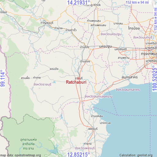
Ratchaburi GPS coordinates[2]
13° 32' 12.156" North, 99° 49' 1.632" East
| Map corner | latitude | longitude |
|---|---|---|
| Upper-left | 14.21931°, | 99.114° |
| Center: | 13.53671°, | 99.81712° |
| Lower-right: | 12.85215°, | 100.52025° |
| Map W x H: | 152×152 km | = 94.4×94.4mi |
| max Lat: | 20.43353° ⇑74.9% North |
| Ratchaburi: | 13.53671° |
| min Lat: | ⇓25.1% South 5.77434° |
| min Long | Ratchaburi | max Long |
| 97.93288° | 99.81712° | 105.49506° |
| W 21.1%⇐ | ⇒78.9% E |
Elevation
Elevation of Ratchaburi is 8 m = 26 ft, and this is 117.5 m = 385 ft below average elevation for this country.
| Max E: |
1011 m = 3317 ft | 91.2% |
| Avg. | 125.5 m = 412 ft | |
| Ratchaburi | 8 m = 26 ft | |
Min E: |
1 m = 3 ft | 8.8% |
See also: Ratchaburi elevation on elevation.city.
Geographical zone
Ratchaburi is located in North Torrid zone (between Equator and Tropic of Cancer). Distance of this Northern Tropic circle is 1100.8 km =684 mi to North.| Distance of | km | miles | from Ratchaburi |
|---|---|---|---|
| North Pole | 8501.9 | 5282.8 | to North |
| Arctic Circle | 5896 | 3663.6 | to North |
| Tropic Cancer | 1100.8 | 684 | to North |
| Equator | 1505.1 | 935.2 | to South |


Nearby cities:
15 places around Ratchaburi: (largest is in red/bold)
• Amphawa
19.6 km =12.2 mi,  129°
129°
• Ban Laem
40.9 km =25.4 mi,  154°
154°
• Ban Phaeo
32 km =19.9 mi,  79°
79°
• Ban Pong
31.8 km =19.8 mi,  11°
11°
• Bang Khon Thi
15.3 km =9.5 mi,  119°
119°
• Bang Phae
21.1 km =13.1 mi,  35°
35°
• Chom Bueng
26.1 km =16.2 mi,  290°
290°
• Damnoen Saduak
15 km =9.3 mi,  97°
97°
• Khao Yoi
33 km =20.5 mi,  178°
178°
• Nakhon Pathom
39.9 km =24.8 mi, 37°
• Pak Tho
18.4 km =11.4 mi,  172°
172°
• Photharam
17.7 km =11 mi, 11°
• Samut Songkhram
24.2 km =15 mi, 124°
• Tha Maka
40.8 km =25.4 mi,  352°
352°
• Wat Phleng
11.9 km =7.4 mi,  140°
140°
Sources, notices
• [Note1] Compared only with cities in Thailand existing in our database
• [Src1] Map data: © OpenStreetMap contributors (CC-BY-SA)
• [Src2] Other city data from geonames.org with taken over terms of usage.
• [Src3] Geographical zone / Annual Mean Temperature by Robert A. Rohde @ Wikipedia
