Ban Phaeo geodata
Ban Phaeo (Samut Sakhon) is a seat of a second-order administrative division; located in Thailand in Asia/Bangkok (GMT+7) time zone. With population of 41,904 people, there are 73 cities with bigger population in this country. Compared to other cities in Thailand, 74.2% of cities are located further ↑North; 69.2% of cities are located further →East and 96.7% of cities have higher elevation than Ban Phaeo. Note1


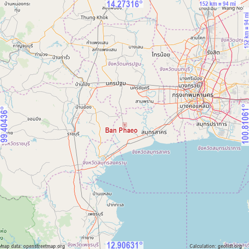
Ban Phaeo GPS coordinates[2]
13° 35' 26.592" North, 100° 6' 26.928" East
| Map corner | latitude | longitude |
|---|---|---|
| Upper-left | 14.27316°, | 99.40436° |
| Center: | 13.59072°, | 100.10748° |
| Lower-right: | 12.90631°, | 100.81061° |
| Map W x H: | 152×152 km | = 94.4×94.4mi |
| max Lat: | 20.43353° ⇑74.2% North |
| Ban Phaeo: | 13.59072° |
| min Lat: | ⇓25.8% South 5.77434° |
| min Long | Ban Phaeo | max Long |
| 97.93288° | 100.10748° | 105.49506° |
| W 30.8%⇐ | ⇒69.2% E |
Elevation
Elevation of Ban Phaeo is 6 m = 20 ft, and this is 119.5 m = 392 ft below average elevation for this country.
| Max E: |
1011 m = 3317 ft | 96.7% |
| Avg. | 125.5 m = 412 ft | |
| Ban Phaeo | 6 m = 20 ft | |
Min E: |
1 m = 3 ft | 3.3% |
See also: Ban Phaeo elevation on elevation.city.
Geographical zone
Ban Phaeo is located in North Torrid zone (between Equator and Tropic of Cancer). Distance of this Northern Tropic circle is 1094.8 km =680.3 mi to North.| Distance of | km | miles | from Ban Phaeo |
|---|---|---|---|
| North Pole | 8495.9 | 5279.1 | to North |
| Arctic Circle | 5890 | 3659.9 | to North |
| Tropic Cancer | 1094.8 | 680.3 | to North |
| Equator | 1511.1 | 939 | to South |


Nearby cities:
15 places around Ban Phaeo: (largest is in red/bold)
• Amphawa
24.6 km =15.3 mi,  221°
221°
• Bang Bon
32.1 km =19.9 mi,  75°
75°
• Bang Khon Thi
22.6 km =14 mi,  233°
233°
• Bang Phae
22.2 km =13.8 mi,  300°
300°
• Damnoen Saduak
18.4 km =11.4 mi,  243°
243°
• Krathum Baen
17.9 km =11.1 mi,  67°
67°
• Nakhon Chai Si
24.8 km =15.4 mi,  19°
19°
• Nakhon Pathom
26.3 km =16.3 mi,  344°
344°
• Nong Khaem
29.1 km =18.1 mi,  64°
64°
• Photharam
30.1 km =18.7 mi,  292°
292°
• Ratchaburi
32 km =19.9 mi,  259°
259°
• Sam Phran
19.1 km =11.9 mi,  37°
37°
• Samut Sakhon
18.6 km =11.6 mi,  104°
104°
• Samut Songkhram
22.6 km =14 mi,  210°
210°
• Wat Phleng
28.3 km =17.6 mi, 237°
Sources, notices
• [Note1] Compared only with cities in Thailand existing in our database
• [Src1] Map data: © OpenStreetMap contributors (CC-BY-SA)
• [Src2] Other city data from geonames.org with taken over terms of usage.
• [Src3] Geographical zone / Annual Mean Temperature by Robert A. Rohde @ Wikipedia
