Damnoen Saduak geodata
Damnoen Saduak (Ratchaburi) is a seat of a second-order administrative division; located in Thailand in Asia/Bangkok (GMT+7) time zone. With population of 23,296 people, there are 139 cities with bigger population in this country. Compared to other cities in Thailand, 75% of cities are located further ↑North; 74.1% of cities are located further →East and 96.7% of cities have higher elevation than Damnoen Saduak. Note1


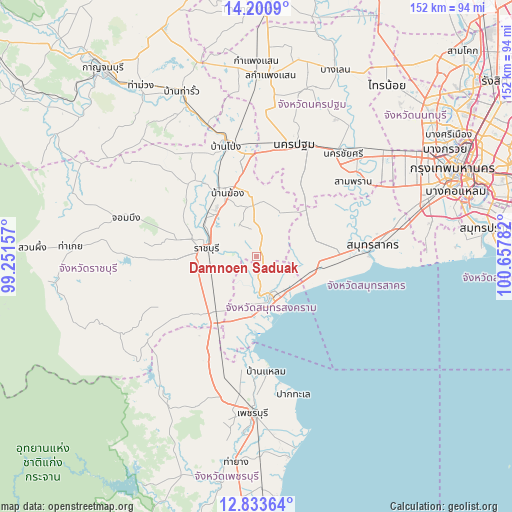
Damnoen Saduak GPS coordinates[2]
13° 31' 5.7" North, 99° 57' 16.884" East
| Map corner | latitude | longitude |
|---|---|---|
| Upper-left | 14.2009°, | 99.25157° |
| Center: | 13.51825°, | 99.95469° |
| Lower-right: | 12.83364°, | 100.65782° |
| Map W x H: | 152×152 km | = 94.4×94.4mi |
| max Lat: | 20.43353° ⇑75% North |
| Damnoen Saduak: | 13.51825° |
| min Lat: | ⇓25% South 5.77434° |
| min Long | Damnoen Saduak | max Long |
| 97.93288° | 99.95469° | 105.49506° |
| W 25.9%⇐ | ⇒74.1% E |
Elevation
Elevation of Damnoen Saduak is 6 m = 20 ft, and this is 119.5 m = 392 ft below average elevation for this country.
| Max E: |
1011 m = 3317 ft | 96.7% |
| Avg. | 125.5 m = 412 ft | |
| Damnoen Saduak | 6 m = 20 ft | |
Min E: |
1 m = 3 ft | 3.3% |
See also: Thailand elevation on elevation.city.
Geographical zone
Damnoen Saduak is located in North Torrid zone (between Equator and Tropic of Cancer). Distance of this Northern Tropic circle is 1102.8 km =685.2 mi to North.| Distance of | km | miles | from Damnoen Saduak |
|---|---|---|---|
| North Pole | 8504 | 5284.1 | to North |
| Arctic Circle | 5898.1 | 3664.9 | to North |
| Tropic Cancer | 1102.8 | 685.2 | to North |
| Equator | 1503.1 | 934 | to South |


Nearby cities:
15 places around Damnoen Saduak: (largest is in red/bold)
• Amphawa
10.4 km =6.5 mi,  178°
178°
• Ban Laem
35 km =21.7 mi, 175°
• Ban Phaeo
18.4 km =11.4 mi,  63°
63°
• Ban Pong
34.2 km =21.3 mi,  345°
345°
• Bang Khon Thi
5.7 km =3.5 mi,  195°
195°
• Bang Phae
19.5 km =12.1 mi, 352°
• Khao Yoi
34 km =21.1 mi, 204°
• Krathum Baen
36.2 km =22.5 mi,  65°
65°
• Nakhon Pathom
34.9 km =21.7 mi,  16°
16°
• Pak Tho
20.4 km =12.7 mi,  217°
217°
• Photharam
22.4 km =13.9 mi,  329°
329°
• Ratchaburi
15 km =9.3 mi,  277°
277°
• Samut Sakhon
34.6 km =21.5 mi,  84°
84°
• Samut Songkhram
12.6 km =7.8 mi,  155°
155°
• Wat Phleng
10.3 km =6.4 mi,  225°
225°
Sources, notices
• [Note1] Compared only with cities in Thailand existing in our database
• [Src1] Map data: © OpenStreetMap contributors (CC-BY-SA)
• [Src2] Other city data from geonames.org with taken over terms of usage.
• [Src3] Geographical zone / Annual Mean Temperature by Robert A. Rohde @ Wikipedia
