Bang Phae geodata
Bang Phae (Ratchaburi) is a seat of a second-order administrative division; located in Thailand in Asia/Bangkok (GMT+7) time zone. With population of 29,548 people, there are 109 cities with bigger population in this country. Compared to other cities in Thailand, 72.4% of cities are located further ↑North; 75% of cities are located further →East and 83.5% of cities have higher elevation than Bang Phae. Note1


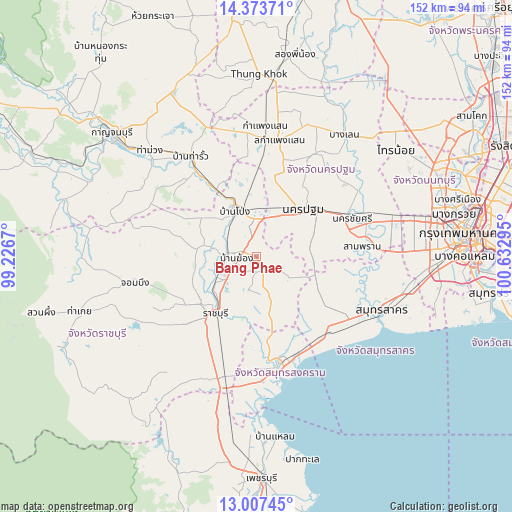
Bang Phae GPS coordinates[2]
13° 41' 29.652" North, 99° 55' 47.352" East
| Map corner | latitude | longitude |
|---|---|---|
| Upper-left | 14.37371°, | 99.2267° |
| Center: | 13.69157°, | 99.92982° |
| Lower-right: | 13.00745°, | 100.63295° |
| Map W x H: | 151.9×151.9 km | = 94.4×94.4mi |
| max Lat: | 20.43353° ⇑72.4% North |
| Bang Phae: | 13.69157° |
| min Lat: | ⇓27.6% South 5.77434° |
| min Long | Bang Phae | max Long |
| 97.93288° | 99.92982° | 105.49506° |
| W 25%⇐ | ⇒75% E |
Elevation
Elevation of Bang Phae is 11 m = 36 ft, and this is 114.5 m = 376 ft below average elevation for this country.
| Max E: |
1011 m = 3317 ft | 83.5% |
| Avg. | 125.5 m = 412 ft | |
| Bang Phae | 11 m = 36 ft | |
Min E: |
1 m = 3 ft | 16.5% |
See also: Thailand elevation on elevation.city.
Geographical zone
Bang Phae is located in North Torrid zone (between Equator and Tropic of Cancer). Distance of this Northern Tropic circle is 1083.6 km =673.3 mi to North.| Distance of | km | miles | from Bang Phae |
|---|---|---|---|
| North Pole | 8484.7 | 5272.1 | to North |
| Arctic Circle | 5878.8 | 3652.9 | to North |
| Tropic Cancer | 1083.6 | 673.3 | to North |
| Equator | 1522.4 | 946 | to South |


Nearby cities:
15 places around Bang Phae: (largest is in red/bold)
• Amphawa
29.9 km =18.6 mi,  174°
174°
• Ban Phaeo
22.2 km =13.8 mi,  120°
120°
• Ban Pong
15 km =9.3 mi,  337°
337°
• Bang Khon Thi
24.8 km =15.4 mi,  177°
177°
• Damnoen Saduak
19.5 km =12.1 mi, 172°
• Don Tum
34 km =21.1 mi,  28°
28°
• Nakhon Chai Si
30.1 km =18.7 mi,  66°
66°
• Nakhon Pathom
18.9 km =11.7 mi,  40°
40°
• Photharam
8.7 km =5.4 mi,  270°
270°
• Ratchaburi
21.1 km =13.1 mi,  215°
215°
• Sam Phran
31.1 km =19.3 mi,  82°
82°
• Samut Songkhram
31.8 km =19.8 mi, 165°
• Tha Maka
29.1 km =18.1 mi,  322°
322°
• Tha Maka
31.1 km =19.3 mi,  325°
325°
• Wat Phleng
26.8 km =16.7 mi,  190°
190°
Sources, notices
• [Note1] Compared only with cities in Thailand existing in our database
• [Src1] Map data: © OpenStreetMap contributors (CC-BY-SA)
• [Src2] Other city data from geonames.org with taken over terms of usage.
• [Src3] Geographical zone / Annual Mean Temperature by Robert A. Rohde @ Wikipedia
