Ban Ao Makham geodata
Ban Ao Makham (Satun) is a populated place; located in Thailand in Asia/Bangkok (GMT+7) time zone. With population of 765 people, there are 327 cities with bigger population in this country. Compared to other cities in Thailand, 97.6% of cities are located further ↑North; 82.5% of cities are located further →East and 83.5% of cities have higher elevation than Ban Ao Makham. Note1


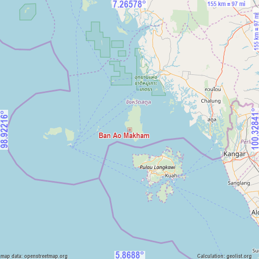
Ban Ao Makham GPS coordinates[2]
6° 34' 4.008" North, 99° 37' 31.008" East
| Map corner | latitude | longitude |
|---|---|---|
| Upper-left | 7.26578°, | 98.92216° |
| Center: | 6.56778°, | 99.62528° |
| Lower-right: | 5.8688°, | 100.32841° |
| Map W x H: | 155.3×155.3 km | = 96.5×96.5mi |
| max Lat: | 20.43353° ⇑97.6% North |
| Ban Ao Makham: | 6.56778° |
| min Lat: | ⇓2.4% South 5.77434° |
| min Long | Ban Ao Makham | max Long |
| 97.93288° | 99.62528° | 105.49506° |
| W 17.5%⇐ | ⇒82.5% E |
Elevation
Elevation of Ban Ao Makham is 11 m = 36 ft, and this is 114.5 m = 376 ft below average elevation for this country.
| Max E: |
1011 m = 3317 ft | 83.5% |
| Avg. | 125.5 m = 412 ft | |
| Ban Ao Makham | 11 m = 36 ft | |
Min E: |
1 m = 3 ft | 16.5% |
See also: Thailand elevation on elevation.city.
Geographical zone
Ban Ao Makham is located in North Torrid zone (between Equator and Tropic of Cancer). Distance of Equator is 730.3 km =453.8 mi to South.| Distance of | km | miles | from Ban Ao Makham |
|---|---|---|---|
| North Pole | 9276.8 | 5764.3 | to North |
| Arctic Circle | 6670.9 | 4145.1 | to North |
| Tropic Cancer | 1875.7 | 1165.5 | to North |
| Equator | 730.3 | 453.8 | to South |


Nearby cities:
15 places around Ban Ao Makham: (largest is in red/bold)
• Hat Samran
75 km =46.6 mi,  355°
355°
• Khlong Hoi Khong
92 km =57.2 mi,  66°
66°
• Khuan Don
55.6 km =34.5 mi,  63°
63°
• Khuan Kalong
58.1 km =36.1 mi, 57°
• La-ngu
39.6 km =24.6 mi,  27°
27°
• Manang
58.1 km =36.1 mi, 34°
• Palian
67.6 km =42 mi,  5°
5°
• Pante Malakar
13.1 km =8.1 mi, 8°
• Sadao
88.5 km =55 mi,  84°
84°
• Satun
49.2 km =30.6 mi, 82°
• Son
6.6 km =4.1 mi,  351°
351°
• Ta Lo Wow
15.6 km =9.7 mi,  16°
16°
• Tha Phae
45.4 km =28.2 mi, 57°
• Thung Wa
61.9 km =38.5 mi, 13°
• Yan Ta Khao
91.1 km =56.6 mi,  2°
2°
Sources, notices
• [Note1] Compared only with cities in Thailand existing in our database
• [Src1] Map data: © OpenStreetMap contributors (CC-BY-SA)
• [Src2] Other city data from geonames.org with taken over terms of usage.
• [Src3] Geographical zone / Annual Mean Temperature by Robert A. Rohde @ Wikipedia
