Sadao geodata
Sadao (Songkhla) is a seat of a second-order administrative division; located in Thailand in Asia/Bangkok (GMT+7) time zone. With population of 46,236 people, there are 64 cities with bigger population in this country. Compared to other cities in Thailand, 97% of cities are located further ↑North; 60.9% of cities are located further →East and 57.9% of cities have higher elevation than Sadao. Note1


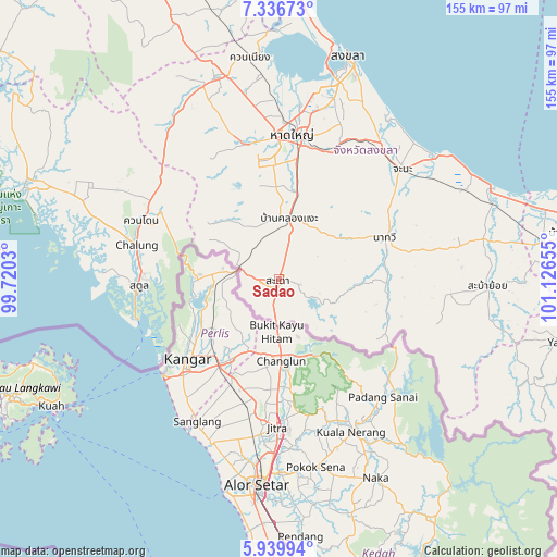
Sadao GPS coordinates[2]
6° 38' 19.788" North, 100° 25' 24.312" East
| Map corner | latitude | longitude |
|---|---|---|
| Upper-left | 7.33673°, | 99.7203° |
| Center: | 6.63883°, | 100.42342° |
| Lower-right: | 5.93994°, | 101.12655° |
| Map W x H: | 155.3×155.3 km | = 96.5×96.5mi |
| max Lat: | 20.43353° ⇑97% North |
| Sadao: | 6.63883° |
| min Lat: | ⇓3% South 5.77434° |
| min Long | Sadao | max Long |
| 97.93288° | 100.42342° | 105.49506° |
| W 39.1%⇐ | ⇒60.9% E |
Elevation
Elevation of Sadao is 50 m = 164 ft, and this is 75.5 m = 248 ft below average elevation for this country.
| Max E: |
1011 m = 3317 ft | 57.9% |
| Avg. | 125.5 m = 412 ft | |
| Sadao | 50 m = 164 ft | |
Min E: |
1 m = 3 ft | 42.1% |
See also: Sadao elevation on elevation.city.
Geographical zone
Sadao is located in North Torrid zone (between Equator and Tropic of Cancer). Distance of Equator is 738.2 km =458.7 mi to South.| Distance of | km | miles | from Sadao |
|---|---|---|---|
| North Pole | 9268.9 | 5759.4 | to North |
| Arctic Circle | 6663 | 4140.2 | to North |
| Tropic Cancer | 1867.8 | 1160.6 | to North |
| Equator | 738.2 | 458.7 | to South |


Nearby cities:
15 places around Sadao: (largest is in red/bold)
• Ban Mai
64.3 km =40 mi,  12°
12°
• Bang Klam
50.1 km =31.1 mi,  358°
358°
• Chana
46.6 km =29 mi,  48°
48°
• Hat Yai
41.5 km =25.8 mi, 8°
• Khlong Hoi Khong
29.1 km =18.1 mi,  352°
352°
• Khuan Don
41.6 km =25.8 mi,  293°
293°
• Khuan Kalong
45.1 km =28 mi,  300°
300°
• Khuan Niang
61.9 km =38.5 mi, 352°
• Na Mom
38.5 km =23.9 mi,  22°
22°
• Na Thawi
31.7 km =19.7 mi,  68°
68°
• Rattaphum
58.1 km =36.1 mi,  341°
341°
• Saba Yoi
58.4 km =36.3 mi,  92°
92°
• Satun
39.4 km =24.5 mi,  267°
267°
• Tha Phae
52.8 km =32.8 mi, 288°
• Thepha
63.4 km =39.4 mi, 70°
Sources, notices
• [Note1] Compared only with cities in Thailand existing in our database
• [Src1] Map data: © OpenStreetMap contributors (CC-BY-SA)
• [Src2] Other city data from geonames.org with taken over terms of usage.
• [Src3] Geographical zone / Annual Mean Temperature by Robert A. Rohde @ Wikipedia
