Khuan Don geodata
Khuan Don (Satun) is a seat of a second-order administrative division; located in Thailand in Asia/Bangkok (GMT+7) time zone. In our database, there are 331 cities with bigger population. Compared to other cities in Thailand, 96.1% of cities are located further ↑North; 70.5% of cities are located further →East and 64.5% of cities have higher elevation than Khuan Don. Note1


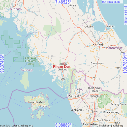
Khuan Don GPS coordinates[2]
6° 47' 15.288" North, 100° 4' 40.008" East
| Map corner | latitude | longitude |
|---|---|---|
| Upper-left | 7.48525°, | 99.37466° |
| Center: | 6.78758°, | 100.07778° |
| Lower-right: | 6.08889°, | 100.78091° |
| Map W x H: | 155.3×155.3 km | = 96.5×96.5mi |
| max Lat: | 20.43353° ⇑96.1% North |
| Khuan Don: | 6.78758° |
| min Lat: | ⇓3.9% South 5.77434° |
| min Long | Khuan Don | max Long |
| 97.93288° | 100.07778° | 105.49506° |
| W 29.5%⇐ | ⇒70.5% E |
Elevation
Elevation of Khuan Don is 33 m = 108 ft, and this is 92.5 m = 303 ft below average elevation for this country.
| Max E: |
1011 m = 3317 ft | 64.5% |
| Avg. | 125.5 m = 412 ft | |
| Khuan Don | 33 m = 108 ft | |
Min E: |
1 m = 3 ft | 35.5% |
See also: Thailand elevation on elevation.city.
Geographical zone
Khuan Don is located in North Torrid zone (between Equator and Tropic of Cancer). Distance of Equator is 754.7 km =468.9 mi to South.| Distance of | km | miles | from Khuan Don |
|---|---|---|---|
| North Pole | 9252.4 | 5749.2 | to North |
| Arctic Circle | 6646.5 | 4129.9 | to North |
| Tropic Cancer | 1851.2 | 1150.3 | to North |
| Equator | 754.7 | 468.9 | to South |


Nearby cities:
15 places around Khuan Don: (largest is in red/bold)
• Bang Klam
49.8 km =30.9 mi,  47°
47°
• Hat Yai
50.4 km =31.3 mi,  60°
60°
• Khlong Hoi Khong
36.5 km =22.7 mi,  70°
70°
• Khuan Kalong
6.5 km =4 mi,  353°
353°
• Khuan Niang
54.2 km =33.7 mi,  34°
34°
• La-ngu
33.7 km =20.9 mi,  288°
288°
• Manang
29.2 km =18.1 mi,  323°
323°
• Pante Malakar
49.3 km =30.6 mi,  256°
256°
• Rattaphum
43.4 km =27 mi, 27°
• Sadao
41.6 km =25.8 mi,  113°
113°
• Satun
18.3 km =11.4 mi,  183°
183°
• Son
54 km =33.6 mi,  250°
250°
• Ta Lo Wow
46.5 km =28.9 mi, 258°
• Tha Phae
11.9 km =7.4 mi,  271°
271°
• Thung Wa
50.4 km =31.3 mi, 315°
Sources, notices
• [Note1] Compared only with cities in Thailand existing in our database
• [Src1] Map data: © OpenStreetMap contributors (CC-BY-SA)
• [Src2] Other city data from geonames.org with taken over terms of usage.
• [Src3] Geographical zone / Annual Mean Temperature by Robert A. Rohde @ Wikipedia
