Ban Mai geodata
Ban Mai (Songkhla) is a populated place; located in Thailand in Asia/Bangkok (GMT+7) time zone. With population of 86,899 people, there are 26 cities with bigger population in this country. Compared to other cities in Thailand, 94.1% of cities are located further ↑North; 55.7% of cities are located further →East and 96.7% of cities have higher elevation than Ban Mai. Note1


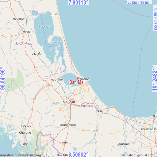
Ban Mai GPS coordinates[2]
7° 12' 14.796" North, 100° 32' 42.288" East
| Map corner | latitude | longitude |
|---|---|---|
| Upper-left | 7.90113°, | 99.84196° |
| Center: | 7.20411°, | 100.54508° |
| Lower-right: | 6.50602°, | 101.24821° |
| Map W x H: | 155.1×155.1 km | = 96.4×96.4mi |
| max Lat: | 20.43353° ⇑94.1% North |
| Ban Mai: | 7.20411° |
| min Lat: | ⇓5.9% South 5.77434° |
| min Long | Ban Mai | max Long |
| 97.93288° | 100.54508° | 105.49506° |
| W 44.3%⇐ | ⇒55.7% E |
Elevation
Elevation of Ban Mai is 6 m = 20 ft, and this is 119.5 m = 392 ft below average elevation for this country.
| Max E: |
1011 m = 3317 ft | 96.7% |
| Avg. | 125.5 m = 412 ft | |
| Ban Mai | 6 m = 20 ft | |
Min E: |
1 m = 3 ft | 3.3% |
See also: Ban Mai elevation on elevation.city.
Geographical zone
Ban Mai is located in North Torrid zone (between Equator and Tropic of Cancer). Distance of Equator is 801 km =497.7 mi to South.| Distance of | km | miles | from Ban Mai |
|---|---|---|---|
| North Pole | 9206 | 5720.3 | to North |
| Arctic Circle | 6600.2 | 4101.2 | to North |
| Tropic Cancer | 1804.9 | 1121.5 | to North |
| Equator | 801 | 497.7 | to South |


Nearby cities:
15 places around Ban Mai: (largest is in red/bold)
• Bang Kaeo
47.6 km =29.6 mi,  301°
301°
• Bang Klam
19.5 km =12.1 mi,  229°
229°
• Chana
38.7 km =24 mi,  146°
146°
• Hat Yai
23 km =14.3 mi,  199°
199°
• Khlong Hoi Khong
38.1 km =23.7 mi,  206°
206°
• Khuan Niang
21.2 km =13.2 mi,  266°
266°
• Krasae Sin
51.6 km =32.1 mi,  332°
332°
• Na Mom
27.3 km =17 mi,  177°
177°
• Pa Bon
42 km =26.1 mi,  279°
279°
• Pak Phayun
29.4 km =18.3 mi, 301°
• Rattaphum
32.8 km =20.4 mi,  256°
256°
• Sathing Phra
32.1 km =19.9 mi,  338°
338°
• Singhanakhon
4 km =2.5 mi,  12°
12°
• Songkhla
5.5 km =3.4 mi,  96°
96°
• Tamot
50.1 km =31.1 mi,  287°
287°
Sources, notices
• [Note1] Compared only with cities in Thailand existing in our database
• [Src1] Map data: © OpenStreetMap contributors (CC-BY-SA)
• [Src2] Other city data from geonames.org with taken over terms of usage.
• [Src3] Geographical zone / Annual Mean Temperature by Robert A. Rohde @ Wikipedia
