Pak Phayun geodata
Pak Phayun (Phatthalung) is a seat of a second-order administrative division; located in Thailand in Asia/Bangkok (GMT+7) time zone. In our database, there are 331 cities with bigger population. Compared to other cities in Thailand, 93.6% of cities are located further ↑North; 64.1% of cities are located further →East and 91.2% of cities have higher elevation than Pak Phayun. Note1


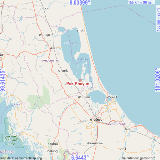
Pak Phayun GPS coordinates[2]
7° 20' 31.884" North, 100° 19' 2.892" East
| Map corner | latitude | longitude |
|---|---|---|
| Upper-left | 8.03899°, | 99.61435° |
| Center: | 7.34219°, | 100.31747° |
| Lower-right: | 6.6443°, | 101.0206° |
| Map W x H: | 155.1×155.1 km | = 96.4×96.4mi |
| max Lat: | 20.43353° ⇑93.6% North |
| Pak Phayun: | 7.34219° |
| min Lat: | ⇓6.4% South 5.77434° |
| min Long | Pak Phayun | max Long |
| 97.93288° | 100.31747° | 105.49506° |
| W 35.9%⇐ | ⇒64.1% E |
Elevation
Elevation of Pak Phayun is 8 m = 26 ft, and this is 117.5 m = 385 ft below average elevation for this country.
| Max E: |
1011 m = 3317 ft | 91.2% |
| Avg. | 125.5 m = 412 ft | |
| Pak Phayun | 8 m = 26 ft | |
Min E: |
1 m = 3 ft | 8.8% |
See also: Thailand elevation on elevation.city.
Geographical zone
Pak Phayun is located in North Torrid zone (between Equator and Tropic of Cancer). Distance of Equator is 816.4 km =507.3 mi to South.| Distance of | km | miles | from Pak Phayun |
|---|---|---|---|
| North Pole | 9190.7 | 5710.8 | to North |
| Arctic Circle | 6584.8 | 4091.6 | to North |
| Tropic Cancer | 1789.5 | 1111.9 | to North |
| Equator | 816.4 | 507.3 | to South |


Nearby cities:
15 places around Pak Phayun: (largest is in red/bold)
• Ban Mai
29.4 km =18.3 mi,  121°
121°
• Bang Kaeo
18.2 km =11.3 mi,  302°
302°
• Bang Klam
29.9 km =18.6 mi,  159°
159°
• Hat Yai
41.1 km =25.5 mi,  154°
154°
• Khao Chaison
24.2 km =15 mi, 303°
• Khuan Niang
17.2 km =10.7 mi,  166°
166°
• Kong Ra
41.1 km =25.5 mi,  279°
279°
• Krasae Sin
30.4 km =18.9 mi,  2°
2°
• Pa Bon
18.1 km =11.2 mi,  243°
243°
• Phatthalung
40.5 km =25.2 mi,  319°
319°
• Rattaphum
24 km =14.9 mi,  196°
196°
• Sathing Phra
19.8 km =12.3 mi,  42°
42°
• Singhanakhon
28.4 km =17.6 mi,  113°
113°
• Songkhla
34.5 km =21.4 mi, 117°
• Tamot
22.7 km =14.1 mi,  269°
269°
Sources, notices
• [Note1] Compared only with cities in Thailand existing in our database
• [Src1] Map data: © OpenStreetMap contributors (CC-BY-SA)
• [Src2] Other city data from geonames.org with taken over terms of usage.
• [Src3] Geographical zone / Annual Mean Temperature by Robert A. Rohde @ Wikipedia
