Songkhla geodata
Songkhla is a seat of a first-order administrative division; located in Thailand in Asia/Bangkok (GMT+7) time zone. With population of 84,264 people, there are 27 cities with bigger population in this country. Compared to other cities in Thailand, 94.2% of cities are located further ↑North; 54.1% of cities are located further →East and 80.8% of cities have higher elevation than Songkhla. Note1


Songkhla GPS coordinates[2]
7° 11' 55.752" North, 100° 35' 42.36" East
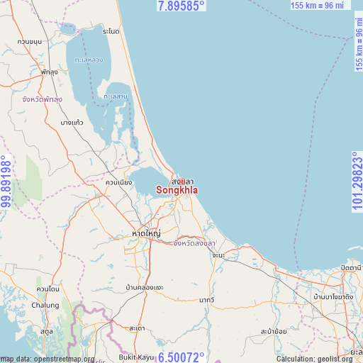
| Map corner | latitude | longitude |
|---|---|---|
| Upper-left | 7.89585°, | 99.89198° |
| Center: | 7.19882°, | 100.5951° |
| Lower-right: | 6.50072°, | 101.29823° |
| Map W x H: | 155.1×155.1 km | = 96.4×96.4mi |
| max Lat: | 20.43353° ⇑94.2% North |
| Songkhla: | 7.19882° |
| min Lat: | ⇓5.8% South 5.77434° |
| min Long | Songkhla | max Long |
| 97.93288° | 100.5951° | 105.49506° |
| W 45.9%⇐ | ⇒54.1% E |
Elevation
Elevation of Songkhla is 12 m = 39 ft, and this is 113.5 m = 372 ft below average elevation for this country.
| Max E: |
1011 m = 3317 ft | 80.8% |
| Avg. | 125.5 m = 412 ft | |
| Songkhla | 12 m = 39 ft | |
Min E: |
1 m = 3 ft | 19.2% |
See also: Songkhla elevation on elevation.city.
Geographical zone
Songkhla is located in North Torrid zone (between Equator and Tropic of Cancer). Distance of Equator is 800.4 km =497.3 mi to South.| Distance of | km | miles | from Songkhla |
|---|---|---|---|
| North Pole | 9206.6 | 5720.7 | to North |
| Arctic Circle | 6600.7 | 4101.5 | to North |
| Tropic Cancer | 1805.5 | 1121.9 | to North |
| Equator | 800.4 | 497.3 | to South |


Nearby cities:
15 places around Songkhla: (largest is in red/bold)
• Ban Mai
5.5 km =3.4 mi,  276°
276°
• Bang Kaeo
52.7 km =32.7 mi,  299°
299°
• Bang Klam
23.7 km =14.7 mi,  239°
239°
• Chana
35.4 km =22 mi,  153°
153°
• Hat Yai
24.9 km =15.5 mi,  211°
211°
• Khlong Hoi Khong
40.4 km =25.1 mi, 214°
• Khuan Niang
26.7 km =16.6 mi,  268°
268°
• Krasae Sin
54.9 km =34.1 mi,  327°
327°
• Na Mom
27 km =16.8 mi,  188°
188°
• Na Thawi
51.9 km =32.2 mi,  168°
168°
• Pa Bon
47.5 km =29.5 mi, 279°
• Pak Phayun
34.5 km =21.4 mi, 297°
• Rattaphum
38 km =23.6 mi,  259°
259°
• Sathing Phra
35 km =21.7 mi, 330°
• Singhanakhon
6.5 km =4 mi,  313°
313°
Sources, notices
• [Note1] Compared only with cities in Thailand existing in our database
• [Src1] Map data: © OpenStreetMap contributors (CC-BY-SA)
• [Src2] Other city data from geonames.org with taken over terms of usage.
• [Src3] Geographical zone / Annual Mean Temperature by Robert A. Rohde @ Wikipedia
