Hat Yai geodata
Hat Yai (Songkhla) is a seat of a second-order administrative division; located in Thailand in Asia/Bangkok (GMT+7) time zone. With population of 191,696 people, there are 7 cities with bigger population in this country. Compared to other cities in Thailand, 94.8% of cities are located further ↑North; 59.4% of cities are located further →East and 80.8% of cities have higher elevation than Hat Yai. Note1


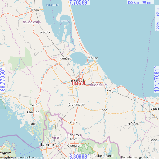
Hat Yai GPS coordinates[2]
7° 0' 30.096" North, 100° 28' 36.048" East
| Map corner | latitude | longitude |
|---|---|---|
| Upper-left | 7.70569°, | 99.77356° |
| Center: | 7.00836°, | 100.47668° |
| Lower-right: | 6.30998°, | 101.17981° |
| Map W x H: | 155.2×155.2 km | = 96.4×96.4mi |
| max Lat: | 20.43353° ⇑94.8% North |
| Hat Yai: | 7.00836° |
| min Lat: | ⇓5.2% South 5.77434° |
| min Long | Hat Yai | max Long |
| 97.93288° | 100.47668° | 105.49506° |
| W 40.6%⇐ | ⇒59.4% E |
Elevation
Elevation of Hat Yai is 12 m = 39 ft, and this is 113.5 m = 372 ft below average elevation for this country.
| Max E: |
1011 m = 3317 ft | 80.8% |
| Avg. | 125.5 m = 412 ft | |
| Hat Yai | 12 m = 39 ft | |
Min E: |
1 m = 3 ft | 19.2% |
See also: Hat Yai elevation on elevation.city.
Geographical zone
Hat Yai is located in North Torrid zone (between Equator and Tropic of Cancer). Distance of Equator is 779.3 km =484.2 mi to South.| Distance of | km | miles | from Hat Yai |
|---|---|---|---|
| North Pole | 9227.8 | 5733.9 | to North |
| Arctic Circle | 6621.9 | 4114.7 | to North |
| Tropic Cancer | 1826.7 | 1135.1 | to North |
| Equator | 779.3 | 484.2 | to South |


Nearby cities:
15 places around Hat Yai: (largest is in red/bold)
• Ban Mai
23 km =14.3 mi,  19°
19°
• Bang Klam
11.6 km =7.2 mi,  321°
321°
• Chana
30.9 km =19.2 mi,  109°
109°
• Khlong Hoi Khong
15.6 km =9.7 mi,  218°
218°
• Khuan Don
50.4 km =31.3 mi,  240°
240°
• Khuan Kalong
48.3 km =30 mi,  247°
247°
• Khuan Niang
24.5 km =15.2 mi,  326°
326°
• Na Mom
10.4 km =6.5 mi,  122°
122°
• Na Thawi
37.9 km =23.5 mi,  141°
141°
• Pa Bon
44.6 km =27.7 mi,  310°
310°
• Pak Phayun
41.1 km =25.5 mi, 334°
• Rattaphum
28.1 km =17.5 mi,  300°
300°
• Sadao
41.5 km =25.8 mi,  188°
188°
• Singhanakhon
27 km =16.8 mi, 18°
• Songkhla
24.9 km =15.5 mi,  31°
31°
Sources, notices
• [Note1] Compared only with cities in Thailand existing in our database
• [Src1] Map data: © OpenStreetMap contributors (CC-BY-SA)
• [Src2] Other city data from geonames.org with taken over terms of usage.
• [Src3] Geographical zone / Annual Mean Temperature by Robert A. Rohde @ Wikipedia
