Khu Mueang geodata
Khu Mueang (Buriram) is a seat of a second-order administrative division; located in Thailand in Asia/Bangkok (GMT+7) time zone. In our database, there are 331 cities with bigger population. Compared to other cities in Thailand, 54.4% of cities are located further ↓South; 78.6% of cities are located further ←West and 74.9% of cities have lower elevation than Khu Mueang. Note1


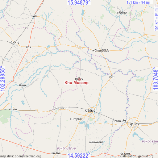
Khu Mueang GPS coordinates[2]
15° 16' 17.76" North, 103° 0' 6.012" East
| Map corner | latitude | longitude |
|---|---|---|
| Upper-left | 15.94879°, | 102.29855° |
| Center: | 15.2716°, | 103.00167° |
| Lower-right: | 14.59222°, | 103.7048° |
| Map W x H: | 150.8×150.8 km | = 93.7×93.7mi |
| max Lat: | 20.43353° ⇑45.6% North |
| Khu Mueang: | 15.2716° |
| min Lat: | ⇓54.4% South 5.77434° |
| min Long | Khu Mueang | max Long |
| 97.93288° | 103.00167° | 105.49506° |
| W 78.6%⇐ | ⇒21.4% E |
Elevation
Elevation of Khu Mueang is 182 m = 597 ft, and this is 56.5 m = 185 ft above average elevation for this country.
| Max E: |
1011 m = 3317 ft | 25.1% |
| Khu Mueang | 182 m 597 ft | |
| Avg. | 125.5 m = 412 ft | |
Min E: |
1 m = 3 ft | 74.9% |
See also: Thailand elevation on elevation.city.
Geographical zone
Khu Mueang is located in North Torrid zone (between Equator and Tropic of Cancer). Distance of this Northern Tropic circle is 907.9 km =564.1 mi to North.| Distance of | km | miles | from Khu Mueang |
|---|---|---|---|
| North Pole | 8309 | 5163 | to North |
| Arctic Circle | 5703.1 | 3543.7 | to North |
| Tropic Cancer | 907.9 | 564.1 | to North |
| Equator | 1698 | 1055.1 | to South |


Nearby cities:
15 places around Khu Mueang: (largest is in red/bold)
• Ban Dan
26 km =16.2 mi,  134°
134°
• Ban Mai Chaiyaphot
38.1 km =23.7 mi,  331°
331°
• Buri Ram
32.7 km =20.3 mi,  160°
160°
• Chum Phuang
29.2 km =18.1 mi,  287°
287°
• Chumphon Buri
42.7 km =26.5 mi,  78°
78°
• Huai Rat
40 km =24.9 mi,  149°
149°
• Khaen Dong
15.3 km =9.5 mi,  67°
67°
• Lam Plai Mat
32.5 km =20.2 mi,  212°
212°
• Lam Thamen Chai
12.8 km =8 mi,  315°
315°
• Mueang Yang
20.3 km =12.6 mi, 324°
• Na Pho
41.4 km =25.7 mi,  353°
353°
• Phayakkhaphum Phisai
34.1 km =21.2 mi,  37°
37°
• Phutthaisong
30.8 km =19.1 mi,  4°
4°
• Prathai
41.7 km =25.9 mi,  314°
314°
• Satuek
31.3 km =19.4 mi, 84°
Sources, notices
• [Note1] Compared only with cities in Thailand existing in our database
• [Src1] Map data: © OpenStreetMap contributors (CC-BY-SA)
• [Src2] Other city data from geonames.org with taken over terms of usage.
• [Src3] Geographical zone / Annual Mean Temperature by Robert A. Rohde @ Wikipedia
