Kaeng Khoi geodata
Kaeng Khoi (Sara Buri) is a seat of a second-order administrative division; located in Thailand in Asia/Bangkok (GMT+7) time zone. With population of 30,332 people, there are 107 cities with bigger population in this country. Compared to other cities in Thailand, 58.3% of cities are located further ↑North; 54.1% of cities are located further ←West and 69.6% of cities have higher elevation than Kaeng Khoi. Note1


Kaeng Khoi GPS coordinates[2]
14° 35' 10.212" North, 100° 59' 51.288" East
| Map corner | latitude | longitude |
|---|---|---|
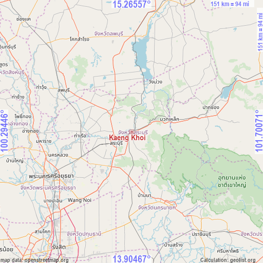
| Upper-left | 15.26557°, | 100.29446° |
| Center: | 14.58617°, | 100.99758° |
| Lower-right: | 13.90467°, | 101.70071° |
| Map W x H: | 151.3×151.3 km | = 94×94mi |
| max Lat: | 20.43353° ⇑58.3% North |
| Kaeng Khoi: | 14.58617° |
| min Lat: | ⇓41.7% South 5.77434° |
| min Long | Kaeng Khoi | max Long |
| 97.93288° | 100.99758° | 105.49506° |
| W 54.1%⇐ | ⇒45.9% E |
Elevation
Elevation of Kaeng Khoi is 23 m = 75 ft, and this is 102.5 m = 336 ft below average elevation for this country.
| Max E: |
1011 m = 3317 ft | 69.6% |
| Avg. | 125.5 m = 412 ft | |
| Kaeng Khoi | 23 m = 75 ft | |
Min E: |
1 m = 3 ft | 30.4% |
See also: Thailand elevation on elevation.city.
Geographical zone
Kaeng Khoi is located in North Torrid zone (between Equator and Tropic of Cancer). Distance of this Northern Tropic circle is 984.1 km =611.5 mi to North.| Distance of | km | miles | from Kaeng Khoi |
|---|---|---|---|
| North Pole | 8385.2 | 5210.3 | to North |
| Arctic Circle | 5779.3 | 3591.1 | to North |
| Tropic Cancer | 984.1 | 611.5 | to North |
| Equator | 1621.8 | 1007.7 | to South |


Nearby cities:
15 places around Kaeng Khoi: (largest is in red/bold)
• Ban Mo
29.3 km =18.2 mi,  276°
276°
• Ban Na
36.9 km =22.9 mi,  167°
167°
• Chaloem Phra Kiat
10 km =6.2 mi,  286°
286°
• Muak Lek
23 km =14.3 mi,  71°
71°
• Nong Don
32.9 km =20.4 mi, 289°
• Nong Khae
30.7 km =19.1 mi,  207°
207°
• Nong Saeng
25.2 km =15.7 mi,  245°
245°
• Phachi
32.7 km =20.3 mi,  242°
242°
• Phatthana Nikhom
30.1 km =18.7 mi,  357°
357°
• Phra Phutthabat
26.7 km =16.6 mi,  305°
305°
• Sao Hai
17 km =10.6 mi,  256°
256°
• Saraburi
10.5 km =6.5 mi, 235°
• Tha Ruea
29.3 km =18.2 mi,  265°
265°
• Wang Muang
31.6 km =19.6 mi,  25°
25°
• Wihan Daeng
26.7 km =16.6 mi,  181°
181°
Sources, notices
• [Note1] Compared only with cities in Thailand existing in our database
• [Src1] Map data: © OpenStreetMap contributors (CC-BY-SA)
• [Src2] Other city data from geonames.org with taken over terms of usage.
• [Src3] Geographical zone / Annual Mean Temperature by Robert A. Rohde @ Wikipedia
