Si That geodata
Si That (Changwat Udon Thani) is a seat of a second-order administrative division; located in Thailand in Asia/Bangkok (GMT+7) time zone. In our database, there are 331 cities with bigger population. Compared to other cities in Thailand, 77.9% of cities are located further ↓South; 81.7% of cities are located further ←West and 75.5% of cities have lower elevation than Si That. Note1


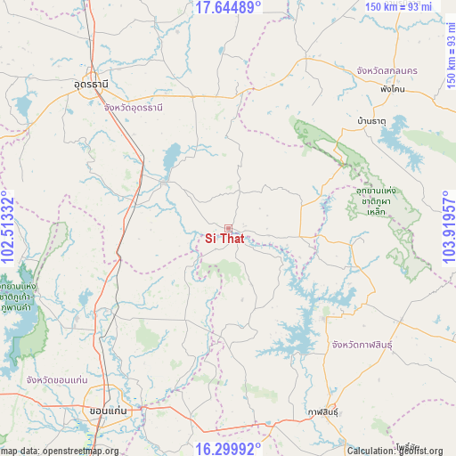
Si That GPS coordinates[2]
16° 58' 24.996" North, 103° 12' 59.184" East
| Map corner | latitude | longitude |
|---|---|---|
| Upper-left | 17.64489°, | 102.51332° |
| Center: | 16.97361°, | 103.21644° |
| Lower-right: | 16.29992°, | 103.91957° |
| Map W x H: | 149.5×149.5 km | = 92.9×92.9mi |
| max Lat: | 20.43353° ⇑22.1% North |
| Si That: | 16.97361° |
| min Lat: | ⇓77.9% South 5.77434° |
| min Long | Si That | max Long |
| 97.93288° | 103.21644° | 105.49506° |
| W 81.7%⇐ | ⇒18.3% E |
Elevation
Elevation of Si That is 183 m = 600 ft, and this is 57.5 m = 189 ft above average elevation for this country.
| Max E: |
1011 m = 3317 ft | 24.5% |
| Si That | 183 m 600 ft | |
| Avg. | 125.5 m = 412 ft | |
Min E: |
1 m = 3 ft | 75.5% |
See also: Thailand elevation on elevation.city.
Geographical zone
Si That is located in North Torrid zone (between Equator and Tropic of Cancer). Distance of this Northern Tropic circle is 718.6 km =446.5 mi to North.| Distance of | km | miles | from Si That |
|---|---|---|---|
| North Pole | 8119.8 | 5045.4 | to North |
| Arctic Circle | 5513.9 | 3426.2 | to North |
| Tropic Cancer | 718.6 | 446.5 | to North |
| Equator | 1887.3 | 1172.7 | to South |


Nearby cities:
15 places around Si That: (largest is in red/bold)
• Ban Na Muang
36.8 km =22.9 mi,  323°
323°
• Ban Nong Wua So
32.7 km =20.3 mi,  1°
1°
• Ban Phan Don
32 km =19.9 mi,  305°
305°
• Chaiwan
35.7 km =22.2 mi, 2°
• Huai Mek
42.7 km =26.5 mi,  177°
177°
• Kranuan
33.1 km =20.6 mi,  206°
206°
• Ku Kaeo
23.1 km =14.4 mi,  343°
343°
• Kumphawapi
26.2 km =16.3 mi, 305°
• Non Sa-at
34.3 km =21.3 mi,  271°
271°
• Nong Kung Si
37.1 km =23.1 mi,  166°
166°
• Sahatsakhan
43.5 km =27 mi,  131°
131°
• Sam Chai
36.6 km =22.7 mi,  109°
109°
• Samran
36.6 km =22.7 mi, 109°
• Tha Khantho
4.9 km =3 mi,  140°
140°
• Wang Sam Mo
23.5 km =14.6 mi,  95°
95°
Sources, notices
• [Note1] Compared only with cities in Thailand existing in our database
• [Src1] Map data: © OpenStreetMap contributors (CC-BY-SA)
• [Src2] Other city data from geonames.org with taken over terms of usage.
• [Src3] Geographical zone / Annual Mean Temperature by Robert A. Rohde @ Wikipedia
