Nong Kung Si geodata
Nong Kung Si (Kalasin) is a populated place; located in Thailand in Asia/Bangkok (GMT+7) time zone. With population of 17,001 people, there are 188 cities with bigger population in this country. Compared to other cities in Thailand, 73.9% of cities are located further ↓South; 82.7% of cities are located further ←West and 75.5% of cities have lower elevation than Nong Kung Si. Note1


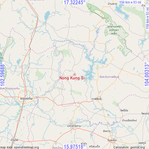
Nong Kung Si GPS coordinates[2]
16° 39' 0" North, 103° 18' 0" East
| Map corner | latitude | longitude |
|---|---|---|
| Upper-left | 17.32245°, | 102.59688° |
| Center: | 16.65°, | 103.3° |
| Lower-right: | 15.97518°, | 104.00313° |
| Map W x H: | 149.8×149.8 km | = 93.1×93.1mi |
| max Lat: | 20.43353° ⇑26.1% North |
| Nong Kung Si: | 16.65° |
| min Lat: | ⇓73.9% South 5.77434° |
| min Long | Nong Kung Si | max Long |
| 97.93288° | 103.3° | 105.49506° |
| W 82.7%⇐ | ⇒17.3% E |
Elevation
Elevation of Nong Kung Si is 183 m = 600 ft, and this is 57.5 m = 189 ft above average elevation for this country.
| Max E: |
1011 m = 3317 ft | 24.5% |
| Nong Kung Si | 183 m 600 ft | |
| Avg. | 125.5 m = 412 ft | |
Min E: |
1 m = 3 ft | 75.5% |
See also: Thailand elevation on elevation.city.
Geographical zone
Nong Kung Si is located in North Torrid zone (between Equator and Tropic of Cancer). Distance of this Northern Tropic circle is 754.6 km =468.9 mi to North.| Distance of | km | miles | from Nong Kung Si |
|---|---|---|---|
| North Pole | 8155.8 | 5067.8 | to North |
| Arctic Circle | 5549.9 | 3448.5 | to North |
| Tropic Cancer | 754.6 | 468.9 | to North |
| Equator | 1851.3 | 1150.3 | to South |


Nearby cities:
15 places around Nong Kung Si: (largest is in red/bold)
• Chiang Yuen
34.3 km =21.3 mi,  218°
218°
• Chuen Chom
16.9 km =10.5 mi,  231°
231°
• Huai Mek
9.6 km =6 mi, 225°
• Kalasin
32.7 km =20.3 mi,  137°
137°
• Kamalasai
45.4 km =28.2 mi, 139°
• Kantharawichai
35.9 km =22.3 mi,  180°
180°
• Kranuan
24.4 km =15.2 mi,  284°
284°
• Sahatsakhan
24.5 km =15.2 mi,  73°
73°
• Sam Chai
34.9 km =21.7 mi,  47°
47°
• Sam Sung
26.3 km =16.3 mi,  243°
243°
• Samran
34.9 km =21.7 mi, 47°
• Si That
37.1 km =23.1 mi,  346°
346°
• Tha Khantho
32.7 km =20.3 mi, 349°
• Wang Sam Mo
36.7 km =22.8 mi,  23°
23°
• Yang Talat
28.7 km =17.8 mi,  165°
165°
Sources, notices
• [Note1] Compared only with cities in Thailand existing in our database
• [Src1] Map data: © OpenStreetMap contributors (CC-BY-SA)
• [Src2] Other city data from geonames.org with taken over terms of usage.
• [Src3] Geographical zone / Annual Mean Temperature by Robert A. Rohde @ Wikipedia
