Phu Kradueng geodata
Phu Kradueng (Loei) is a seat of a second-order administrative division; located in Thailand in Asia/Bangkok (GMT+7) time zone. With population of 16,079 people, there are 201 cities with bigger population in this country. Compared to other cities in Thailand, 77% of cities are located further ↓South; 65.6% of cities are located further ←West and 89.4% of cities have lower elevation than Phu Kradueng. Note1


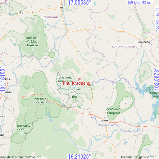
Phu Kradueng GPS coordinates[2]
16° 53' 3.3" North, 101° 53' 4.812" East
| Map corner | latitude | longitude |
|---|---|---|
| Upper-left | 17.55585°, | 101.18155° |
| Center: | 16.88425°, | 101.88467° |
| Lower-right: | 16.21025°, | 102.5878° |
| Map W x H: | 149.6×149.6 km | = 93×93mi |
| max Lat: | 20.43353° ⇑23% North |
| Phu Kradueng: | 16.88425° |
| min Lat: | ⇓77% South 5.77434° |
| min Long | Phu Kradueng | max Long |
| 97.93288° | 101.88467° | 105.49506° |
| W 65.6%⇐ | ⇒34.4% E |
Elevation
Elevation of Phu Kradueng is 268 m = 879 ft, and this is 142.5 m = 468 ft above average elevation for this country.
| Max E: |
1011 m = 3317 ft | 10.6% |
| Phu Kradueng | 268 m 879 ft | |
| Avg. | 125.5 m = 412 ft | |
Min E: |
1 m = 3 ft | 89.4% |
See also: Thailand elevation on elevation.city.
Geographical zone
Phu Kradueng is located in North Torrid zone (between Equator and Tropic of Cancer). Distance of this Northern Tropic circle is 728.6 km =452.7 mi to North.| Distance of | km | miles | from Phu Kradueng |
|---|---|---|---|
| North Pole | 8129.7 | 5051.6 | to North |
| Arctic Circle | 5523.8 | 3432.3 | to North |
| Tropic Cancer | 728.6 | 452.7 | to North |
| Equator | 1877.4 | 1166.6 | to South |


Nearby cities:
15 places around Phu Kradueng: (largest is in red/bold)
• Chum Phae
44.2 km =27.5 mi,  148°
148°
• Erawan
47 km =29.2 mi,  8°
8°
• Khon San
30.4 km =18.9 mi,  173°
173°
• Na Klang
57.1 km =35.5 mi,  34°
34°
• Na Wang
53.1 km =33 mi,  22°
22°
• Nam Nao
26.4 km =16.4 mi,  240°
240°
• Nong Hin
26.8 km =16.7 mi,  353°
353°
• Nong Na Kham
48.9 km =30.4 mi,  100°
100°
• Pha Khao
25.3 km =15.7 mi,  37°
37°
• Phu Luang
36.8 km =22.9 mi,  320°
320°
• Phu Pha Man
26.2 km =16.3 mi,  176°
176°
• Si Bun Rueang
42.6 km =26.5 mi,  77°
77°
• Si Chomphu
33.3 km =20.7 mi,  106°
106°
• Wang Saphung
48 km =29.8 mi, 345°
• Wiang Kao
48.2 km =30 mi,  117°
117°
Sources, notices
• [Note1] Compared only with cities in Thailand existing in our database
• [Src1] Map data: © OpenStreetMap contributors (CC-BY-SA)
• [Src2] Other city data from geonames.org with taken over terms of usage.
• [Src3] Geographical zone / Annual Mean Temperature by Robert A. Rohde @ Wikipedia
