Erawan geodata
Erawan (Loei) is a seat of a second-order administrative division; located in Thailand in Asia/Bangkok (GMT+7) time zone. In our database, there are 331 cities with bigger population. Compared to other cities in Thailand, 82% of cities are located further ↓South; 66.3% of cities are located further ←West and 93.7% of cities have lower elevation than Erawan. Note1


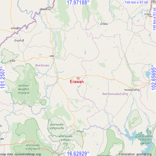
Erawan GPS coordinates[2]
17° 18' 6.516" North, 101° 57' 13.752" East
| Map corner | latitude | longitude |
|---|---|---|
| Upper-left | 17.97188°, | 101.2507° |
| Center: | 17.30181°, | 101.95382° |
| Lower-right: | 16.62929°, | 102.65695° |
| Map W x H: | 149.3×149.3 km | = 92.8×92.8mi |
| max Lat: | 20.43353° ⇑18% North |
| Erawan: | 17.30181° |
| min Lat: | ⇓82% South 5.77434° |
| min Long | Erawan | max Long |
| 97.93288° | 101.95382° | 105.49506° |
| W 66.3%⇐ | ⇒33.7% E |
Elevation
Elevation of Erawan is 358 m = 1175 ft, and this is 232.5 m = 763 ft above average elevation for this country.
| Max E: |
1011 m = 3317 ft | 6.3% |
| Erawan | 358 m 1175 ft | |
| Avg. | 125.5 m = 412 ft | |
Min E: |
1 m = 3 ft | 93.7% |
See also: Thailand elevation on elevation.city.
Geographical zone
Erawan is located in North Torrid zone (between Equator and Tropic of Cancer). Distance of this Northern Tropic circle is 682.1 km =423.8 mi to North.| Distance of | km | miles | from Erawan |
|---|---|---|---|
| North Pole | 8083.3 | 5022.7 | to North |
| Arctic Circle | 5477.4 | 3403.5 | to North |
| Tropic Cancer | 682.1 | 423.8 | to North |
| Equator | 1923.8 | 1195.4 | to South |


Nearby cities:
15 places around Erawan: (largest is in red/bold)
• Loei
31.9 km =19.8 mi,  311°
311°
• Na Klang
25 km =15.5 mi,  88°
88°
• Na Wang
13.5 km =8.4 mi,  79°
79°
• Nam Som
57.8 km =35.9 mi,  25°
25°
• Nong Bua Lamphu
52.8 km =32.8 mi,  101°
101°
• Nong Hin
22.3 km =13.9 mi,  207°
207°
• Pha Khao
27.5 km =17.1 mi,  162°
162°
• Phu Kradueng
47 km =29.2 mi,  188°
188°
• Phu Luang
35.7 km =22.2 mi,  239°
239°
• Phu Ruea
65 km =40.4 mi,  285°
285°
• Si Bun Rueang
50.6 km =31.4 mi,  137°
137°
• Si Chomphu
61.1 km =38 mi, 156°
• Suwanna Khuha
45.2 km =28.1 mi,  49°
49°
• Suwannakhuha
45.2 km =28.1 mi, 49°
• Wang Saphung
19.7 km =12.2 mi,  269°
269°
Sources, notices
• [Note1] Compared only with cities in Thailand existing in our database
• [Src1] Map data: © OpenStreetMap contributors (CC-BY-SA)
• [Src2] Other city data from geonames.org with taken over terms of usage.
• [Src3] Geographical zone / Annual Mean Temperature by Robert A. Rohde @ Wikipedia
