Phon Sai geodata
Phon Sai (Roi Et) is a seat of a second-order administrative division; located in Thailand in Asia/Bangkok (GMT+7) time zone. In our database, there are 331 cities with bigger population. Compared to other cities in Thailand, 58% of cities are located further ↓South; 90.4% of cities are located further ←West and 53.3% of cities have lower elevation than Phon Sai. Note1


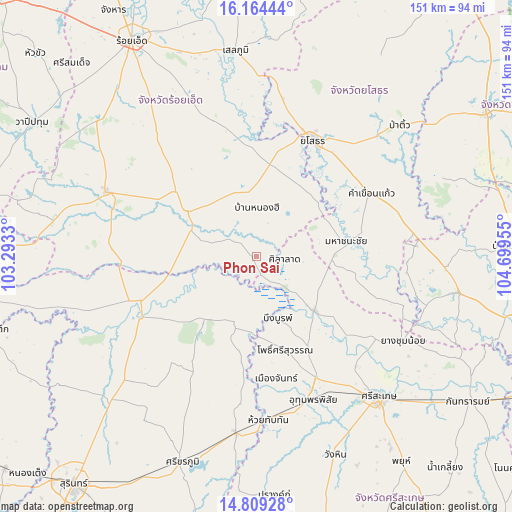
Phon Sai GPS coordinates[2]
15° 29' 16.692" North, 103° 59' 47.112" East
| Map corner | latitude | longitude |
|---|---|---|
| Upper-left | 16.16444°, | 103.2933° |
| Center: | 15.48797°, | 103.99642° |
| Lower-right: | 14.80928°, | 104.69955° |
| Map W x H: | 150.7×150.7 km | = 93.6×93.6mi |
| max Lat: | 20.43353° ⇑42% North |
| Phon Sai: | 15.48797° |
| min Lat: | ⇓58% South 5.77434° |
| min Long | Phon Sai | max Long |
| 97.93288° | 103.99642° | 105.49506° |
| W 90.4%⇐ | ⇒9.6% E |
Elevation
Elevation of Phon Sai is 131 m = 430 ft, and this is 5.5 m = 18 ft above average elevation for this country.
| Max E: |
1011 m = 3317 ft | 46.7% |
| Phon Sai | 131 m 430 ft | |
| Avg. | 125.5 m = 412 ft | |
Min E: |
1 m = 3 ft | 53.3% |
See also: Thailand elevation on elevation.city.
Geographical zone
Phon Sai is located in North Torrid zone (between Equator and Tropic of Cancer). Distance of this Northern Tropic circle is 883.8 km =549.2 mi to North.| Distance of | km | miles | from Phon Sai |
|---|---|---|---|
| North Pole | 8285 | 5148.1 | to North |
| Arctic Circle | 5679.1 | 3528.8 | to North |
| Tropic Cancer | 883.8 | 549.2 | to North |
| Equator | 1722.1 | 1070.1 | to South |


Nearby cities:
15 places around Phon Sai: (largest is in red/bold)
• Bueng Bun
18.3 km =11.4 mi,  163°
163°
• Kham Khuean Kaeo
38.1 km =23.7 mi,  61°
61°
• Kho Wang
40.3 km =25 mi,  108°
108°
• Maha Chana Chai
26.3 km =16.3 mi,  79°
79°
• Mueang Chan
36.8 km =22.9 mi,  173°
173°
• Non Narai
29.2 km =18.1 mi,  197°
197°
• Nong Hi
13.7 km =8.5 mi,  359°
359°
• Phanom Phrai
24.4 km =15.2 mi,  30°
30°
• Pho Si Suwan
30 km =18.6 mi, 163°
• Rasi Salai
23.3 km =14.5 mi,  133°
133°
• Rattanaburi
24.7 km =15.3 mi,  219°
219°
• Sila Lat
8.3 km =5.2 mi,  102°
102°
• Suwannaphum
24.5 km =15.2 mi,  301°
301°
• Tha Tum
39.2 km =24.4 mi,  241°
241°
• Yasothon
37.6 km =23.4 mi, 25°
Sources, notices
• [Note1] Compared only with cities in Thailand existing in our database
• [Src1] Map data: © OpenStreetMap contributors (CC-BY-SA)
• [Src2] Other city data from geonames.org with taken over terms of usage.
• [Src3] Geographical zone / Annual Mean Temperature by Robert A. Rohde @ Wikipedia
