Phon geodata
Phon (Khon Kaen) is a seat of a second-order administrative division; located in Thailand in Asia/Bangkok (GMT+7) time zone. With population of 14,596 people, there are 223 cities with bigger population in this country. Compared to other cities in Thailand, 62.8% of cities are located further ↓South; 74.6% of cities are located further ←West and 72.8% of cities have lower elevation than Phon. Note1


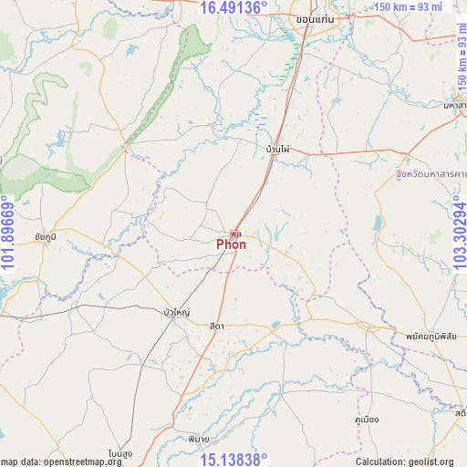
Phon GPS coordinates[2]
15° 48' 57.6" North, 102° 35' 59.316" East
| Map corner | latitude | longitude |
|---|---|---|
| Upper-left | 16.49136°, | 101.89669° |
| Center: | 15.816°, | 102.59981° |
| Lower-right: | 15.13838°, | 103.30294° |
| Map W x H: | 150.4×150.4 km | = 93.5×93.5mi |
| max Lat: | 20.43353° ⇑37.2% North |
| Phon: | 15.816° |
| min Lat: | ⇓62.8% South 5.77434° |
| min Long | Phon | max Long |
| 97.93288° | 102.59981° | 105.49506° |
| W 74.6%⇐ | ⇒25.4% E |
Elevation
Elevation of Phon is 177 m = 581 ft, and this is 51.5 m = 169 ft above average elevation for this country.
| Max E: |
1011 m = 3317 ft | 27.2% |
| Phon | 177 m 581 ft | |
| Avg. | 125.5 m = 412 ft | |
Min E: |
1 m = 3 ft | 72.8% |
See also: Thailand elevation on elevation.city.
Geographical zone
Phon is located in North Torrid zone (between Equator and Tropic of Cancer). Distance of this Northern Tropic circle is 847.3 km =526.5 mi to North.| Distance of | km | miles | from Phon |
|---|---|---|---|
| North Pole | 8248.5 | 5125.4 | to North |
| Arctic Circle | 5642.6 | 3506.1 | to North |
| Tropic Cancer | 847.3 | 526.5 | to North |
| Equator | 1758.6 | 1092.7 | to South |


Nearby cities:
15 places around Phon: (largest is in red/bold)
• Ban Mai Chaiyaphot
36.8 km =22.9 mi,  137°
137°
• Ban Phai
30.5 km =19 mi,  27°
27°
• Bua Lai
19.9 km =12.4 mi,  212°
212°
• Bua Yai
31.7 km =19.7 mi,  215°
215°
• Chonnabot
30.4 km =18.9 mi,  4°
4°
• Kaeng Sanam Nang
37.6 km =23.4 mi,  258°
258°
• Khok Pho Chai
36.7 km =22.8 mi,  324°
324°
• Khon Sawan
36.4 km =22.6 mi,  290°
290°
• Mancha Khiri
35.6 km =22.1 mi,  349°
349°
• Non Sila
19.1 km =11.9 mi,  23°
23°
• Prathai
34.1 km =21.2 mi,  157°
157°
• Pueai Noi
33.5 km =20.8 mi,  79°
79°
• Sida
29.8 km =18.5 mi,  186°
186°
• Waeng Noi
19.7 km =12.2 mi,  265°
265°
• Waeng Yai
16.5 km =10.3 mi,  339°
339°
Sources, notices
• [Note1] Compared only with cities in Thailand existing in our database
• [Src1] Map data: © OpenStreetMap contributors (CC-BY-SA)
• [Src2] Other city data from geonames.org with taken over terms of usage.
• [Src3] Geographical zone / Annual Mean Temperature by Robert A. Rohde @ Wikipedia
