Pueai Noi geodata
Pueai Noi (Khon Kaen) is a seat of a second-order administrative division; located in Thailand in Asia/Bangkok (GMT+7) time zone. With population of 4,468 people, there are 316 cities with bigger population in this country. Compared to other cities in Thailand, 64% of cities are located further ↓South; 78.1% of cities are located further ←West and 79.7% of cities have lower elevation than Pueai Noi. Note1


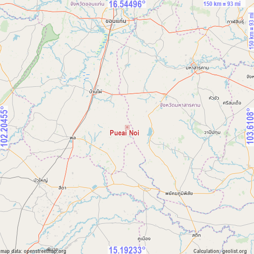
Pueai Noi GPS coordinates[2]
15° 52' 11.208" North, 102° 54' 27.612" East
| Map corner | latitude | longitude |
|---|---|---|
| Upper-left | 16.54496°, | 102.20455° |
| Center: | 15.86978°, | 102.90767° |
| Lower-right: | 15.19233°, | 103.6108° |
| Map W x H: | 150.4×150.4 km | = 93.5×93.5mi |
| max Lat: | 20.43353° ⇑36% North |
| Pueai Noi: | 15.86978° |
| min Lat: | ⇓64% South 5.77434° |
| min Long | Pueai Noi | max Long |
| 97.93288° | 102.90767° | 105.49506° |
| W 78.1%⇐ | ⇒21.9% E |
Elevation
Elevation of Pueai Noi is 196 m = 643 ft, and this is 70.5 m = 231 ft above average elevation for this country.
| Max E: |
1011 m = 3317 ft | 20.3% |
| Pueai Noi | 196 m 643 ft | |
| Avg. | 125.5 m = 412 ft | |
Min E: |
1 m = 3 ft | 79.7% |
See also: Thailand elevation on elevation.city.
Geographical zone
Pueai Noi is located in North Torrid zone (between Equator and Tropic of Cancer). Distance of this Northern Tropic circle is 841.4 km =522.8 mi to North.| Distance of | km | miles | from Pueai Noi |
|---|---|---|---|
| North Pole | 8242.5 | 5121.7 | to North |
| Arctic Circle | 5636.6 | 3502.4 | to North |
| Tropic Cancer | 841.4 | 522.8 | to North |
| Equator | 1764.6 | 1096.5 | to South |


Nearby cities:
15 places around Pueai Noi: (largest is in red/bold)
• Ban Haet
39.6 km =24.6 mi,  336°
336°
• Ban Mai Chaiyaphot
33.9 km =21.1 mi,  193°
193°
• Ban Phai
28.4 km =17.6 mi,  318°
318°
• Borabue
29.3 km =18.2 mi,  49°
49°
• Chonnabot
39.1 km =24.3 mi,  308°
308°
• Kut Rang
27.2 km =16.9 mi,  23°
23°
• Na Chueak
15.8 km =9.8 mi,  122°
122°
• Na Dun
38.2 km =23.7 mi, 116°
• Na Pho
25.9 km =16.1 mi,  168°
168°
• Non Sila
28 km =17.4 mi,  294°
294°
• Phon
33.5 km =20.8 mi,  259°
259°
• Phutthaisong
37.9 km =23.5 mi,  160°
160°
• Prathai
42.3 km =26.3 mi,  207°
207°
• Waeng Yai
39.7 km =24.7 mi,  283°
283°
• Yang Si Surat
29.4 km =18.3 mi,  134°
134°
Sources, notices
• [Note1] Compared only with cities in Thailand existing in our database
• [Src1] Map data: © OpenStreetMap contributors (CC-BY-SA)
• [Src2] Other city data from geonames.org with taken over terms of usage.
• [Src3] Geographical zone / Annual Mean Temperature by Robert A. Rohde @ Wikipedia
