Sung Noen geodata
Sung Noen (Nakhon Ratchasima) is a seat of a second-order administrative division; located in Thailand in Asia/Bangkok (GMT+7) time zone. With population of 14,365 people, there are 228 cities with bigger population in this country. Compared to other cities in Thailand, 51.7% of cities are located further ↑North; 64.7% of cities are located further ←West and 84.6% of cities have lower elevation than Sung Noen. Note1


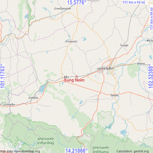
Sung Noen GPS coordinates[2]
14° 53' 57.12" North, 101° 49' 14.7" East
| Map corner | latitude | longitude |
|---|---|---|
| Upper-left | 15.5776°, | 101.11763° |
| Center: | 14.8992°, | 101.82075° |
| Lower-right: | 14.21866°, | 102.52388° |
| Map W x H: | 151.1×151.1 km | = 93.9×93.9mi |
| max Lat: | 20.43353° ⇑51.7% North |
| Sung Noen: | 14.8992° |
| min Lat: | ⇓48.3% South 5.77434° |
| min Long | Sung Noen | max Long |
| 97.93288° | 101.82075° | 105.49506° |
| W 64.7%⇐ | ⇒35.3% E |
Elevation
Elevation of Sung Noen is 216 m = 709 ft, and this is 90.5 m = 297 ft above average elevation for this country.
| Max E: |
1011 m = 3317 ft | 15.4% |
| Sung Noen | 216 m 709 ft | |
| Avg. | 125.5 m = 412 ft | |
Min E: |
1 m = 3 ft | 84.6% |
See also: Thailand elevation on elevation.city.
Geographical zone
Sung Noen is located in North Torrid zone (between Equator and Tropic of Cancer). Distance of this Northern Tropic circle is 949.3 km =589.9 mi to North.| Distance of | km | miles | from Sung Noen |
|---|---|---|---|
| North Pole | 8350.4 | 5188.7 | to North |
| Arctic Circle | 5744.5 | 3569.5 | to North |
| Tropic Cancer | 949.3 | 589.9 | to North |
| Equator | 1656.6 | 1029.4 | to South |


Nearby cities:
15 places around Sung Noen: (largest is in red/bold)
• Amphoe Sikhiu
12.1 km =7.5 mi,  270°
270°
• Chaloem Phra Kiat
49.7 km =30.9 mi,  76°
76°
• Chok Chai
41.6 km =25.8 mi,  117°
117°
• Dan Khun Thot
34.8 km =21.6 mi,  351°
351°
• Kham Sakae Saeng
61.2 km =38 mi,  38°
38°
• Kham Thale So
15.3 km =9.5 mi,  63°
63°
• Nakhon Ratchasima
31.2 km =19.4 mi, 75°
• Non Sung
56.3 km =35 mi, 56°
• Non Thai
42.6 km =26.5 mi, 39°
• Pak Chong
48.4 km =30.1 mi,  243°
243°
• Pak Thong Chai
29.5 km =18.3 mi,  131°
131°
• Phra Thong Kham
46.2 km =28.7 mi,  27°
27°
• Sikhio
10.5 km =6.5 mi, 265°
• Thepharak
54 km =33.6 mi,  327°
327°
• Wang Nam Khiao
53.7 km =33.4 mi,  175°
175°
Sources, notices
• [Note1] Compared only with cities in Thailand existing in our database
• [Src1] Map data: © OpenStreetMap contributors (CC-BY-SA)
• [Src2] Other city data from geonames.org with taken over terms of usage.
• [Src3] Geographical zone / Annual Mean Temperature by Robert A. Rohde @ Wikipedia
