Na Wa geodata
Na Wa (Nakhon Phanom) is a seat of a second-order administrative division; located in Thailand in Asia/Bangkok (GMT+7) time zone. With population of 12,989 people, there are 254 cities with bigger population in this country. Compared to other cities in Thailand, 84.1% of cities are located further ↓South; 91.7% of cities are located further ←West and 65.2% of cities have lower elevation than Na Wa. Note1


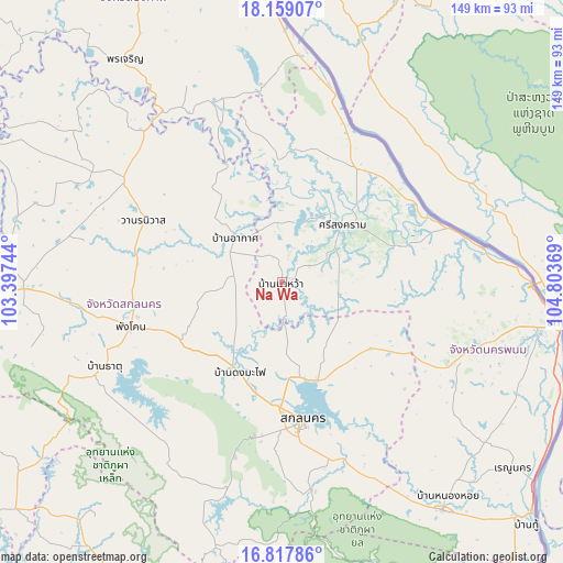
Na Wa GPS coordinates[2]
17° 29' 22.92" North, 104° 6' 2.016" East
| Map corner | latitude | longitude |
|---|---|---|
| Upper-left | 18.15907°, | 103.39744° |
| Center: | 17.4897°, | 104.10056° |
| Lower-right: | 16.81786°, | 104.80369° |
| Map W x H: | 149.1×149.1 km | = 92.6×92.6mi |
| max Lat: | 20.43353° ⇑15.9% North |
| Na Wa: | 17.4897° |
| min Lat: | ⇓84.1% South 5.77434° |
| min Long | Na Wa | max Long |
| 97.93288° | 104.10056° | 105.49506° |
| W 91.7%⇐ | ⇒8.3% E |
Elevation
Elevation of Na Wa is 160 m = 525 ft, and this is 34.5 m = 113 ft above average elevation for this country.
| Max E: |
1011 m = 3317 ft | 34.8% |
| Na Wa | 160 m 525 ft | |
| Avg. | 125.5 m = 412 ft | |
Min E: |
1 m = 3 ft | 65.2% |
See also: Thailand elevation on elevation.city.
Geographical zone
Na Wa is located in North Torrid zone (between Equator and Tropic of Cancer). Distance of this Northern Tropic circle is 661.2 km =410.9 mi to North.| Distance of | km | miles | from Na Wa |
|---|---|---|---|
| North Pole | 8062.4 | 5009.7 | to North |
| Arctic Circle | 5456.5 | 3390.5 | to North |
| Tropic Cancer | 661.2 | 410.9 | to North |
| Equator | 1944.7 | 1208.4 | to South |


Nearby cities:
15 places around Na Wa: (largest is in red/bold)
• Akat Amnuai
17.3 km =10.7 mi,  313°
313°
• Bueng Khong Long
52.7 km =32.7 mi,  353°
353°
• Khok Si Suphan
52.8 km =32.8 mi,  159°
159°
• Kusuman
30.1 km =18.7 mi,  125°
125°
• Na Thom
32.8 km =20.4 mi,  358°
358°
• Nathom
32.9 km =20.4 mi, 358°
• Nikhom Nam Un
53 km =32.9 mi,  229°
229°
• Phang Khon
42.2 km =26.2 mi,  254°
254°
• Phanna Nikhom
30.6 km =19 mi,  240°
240°
• Phon Na Kaeo
36 km =22.4 mi,  146°
146°
• Sakon Nakhon
36.9 km =22.9 mi,  172°
172°
• Seka
51.2 km =31.8 mi,  342°
342°
• Si Songkhram
22.1 km =13.7 mi,  46°
46°
• Tha Uthen
53.7 km =33.4 mi,  79°
79°
• Wanon Niwat
40.2 km =25 mi,  293°
293°
Sources, notices
• [Note1] Compared only with cities in Thailand existing in our database
• [Src1] Map data: © OpenStreetMap contributors (CC-BY-SA)
• [Src2] Other city data from geonames.org with taken over terms of usage.
• [Src3] Geographical zone / Annual Mean Temperature by Robert A. Rohde @ Wikipedia
