Tha Uthen geodata
Tha Uthen (Nakhon Phanom) is a seat of a second-order administrative division; located in Thailand in Asia/Bangkok (GMT+7) time zone. In our database, there are 331 cities with bigger population. Compared to other cities in Thailand, 84.7% of cities are located further ↓South; 96% of cities are located further ←West and 61.5% of cities have lower elevation than Tha Uthen. Note1


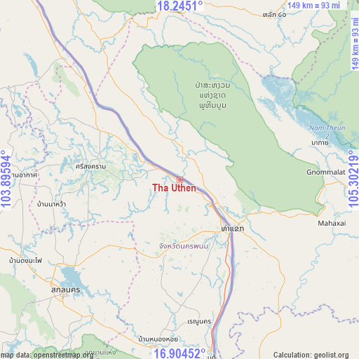
Tha Uthen GPS coordinates[2]
17° 34' 33.78" North, 104° 35' 56.616" East
| Map corner | latitude | longitude |
|---|---|---|
| Upper-left | 18.2451°, | 103.89594° |
| Center: | 17.57605°, | 104.59906° |
| Lower-right: | 16.90452°, | 105.30219° |
| Map W x H: | 149.1×149.1 km | = 92.6×92.6mi |
| max Lat: | 20.43353° ⇑15.3% North |
| Tha Uthen: | 17.57605° |
| min Lat: | ⇓84.7% South 5.77434° |
| min Long | Tha Uthen | max Long |
| 97.93288° | 104.59906° | 105.49506° |
| W 96%⇐ | ⇒4% E |
Elevation
Elevation of Tha Uthen is 151 m = 495 ft, and this is 25.5 m = 84 ft above average elevation for this country.
| Max E: |
1011 m = 3317 ft | 38.5% |
| Tha Uthen | 151 m 495 ft | |
| Avg. | 125.5 m = 412 ft | |
Min E: |
1 m = 3 ft | 61.5% |
See also: Thailand elevation on elevation.city.
Geographical zone
Tha Uthen is located in North Torrid zone (between Equator and Tropic of Cancer). Distance of this Northern Tropic circle is 651.6 km =404.9 mi to North.| Distance of | km | miles | from Tha Uthen |
|---|---|---|---|
| North Pole | 8052.8 | 5003.8 | to North |
| Arctic Circle | 5446.9 | 3384.5 | to North |
| Tropic Cancer | 651.6 | 404.9 | to North |
| Equator | 1954.3 | 1214.3 | to South |


Nearby cities:
15 places around Tha Uthen: (largest is in red/bold)
• Akat Amnuai
65.5 km =40.7 mi,  271°
271°
• Ban Phaeng
59.3 km =36.8 mi,  316°
316°
• Khok Si Suphan
68.3 km =42.4 mi,  210°
210°
• Kusuman
39.2 km =24.4 mi,  226°
226°
• Na Kae
70.8 km =44 mi,  188°
188°
• Na Thom
58.6 km =36.4 mi,  293°
293°
• Na Wa
53.7 km =33.4 mi,  259°
259°
• Nakhon Phanom
26.5 km =16.5 mi,  133°
133°
• Nathom
58.7 km =36.5 mi, 293°
• Phon Na Kaeo
51.3 km =31.9 mi,  219°
219°
• Pla Pak
44.6 km =27.7 mi, 189°
• Renu Nakhon
58.9 km =36.6 mi,  171°
171°
• Sakon Nakhon
66.5 km =41.3 mi, 226°
• Si Songkhram
37.4 km =23.2 mi,  278°
278°
• Wang Yang
59.7 km =37.1 mi,  195°
195°
Sources, notices
• [Note1] Compared only with cities in Thailand existing in our database
• [Src1] Map data: © OpenStreetMap contributors (CC-BY-SA)
• [Src2] Other city data from geonames.org with taken over terms of usage.
• [Src3] Geographical zone / Annual Mean Temperature by Robert A. Rohde @ Wikipedia
