Nakhon Chai Si geodata
Nakhon Chai Si (Nakhon Pathom) is a seat of a second-order administrative division; located in Thailand in Asia/Bangkok (GMT+7) time zone. In our database, there are 331 cities with bigger population. Compared to other cities in Thailand, 68.2% of cities are located further ↑North; 66.8% of cities are located further →East and 96.7% of cities have higher elevation than Nakhon Chai Si. Note1


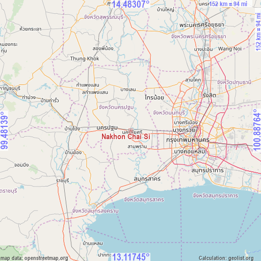
Nakhon Chai Si GPS coordinates[2]
13° 48' 4.536" North, 100° 11' 4.236" East
| Map corner | latitude | longitude |
|---|---|---|
| Upper-left | 14.48307°, | 99.48139° |
| Center: | 13.80126°, | 100.18451° |
| Lower-right: | 13.11745°, | 100.88764° |
| Map W x H: | 151.8×151.8 km | = 94.3×94.3mi |
| max Lat: | 20.43353° ⇑68.2% North |
| Nakhon Chai Si: | 13.80126° |
| min Lat: | ⇓31.8% South 5.77434° |
| min Long | Nakhon Chai Si | max Long |
| 97.93288° | 100.18451° | 105.49506° |
| W 33.2%⇐ | ⇒66.8% E |
Elevation
Elevation of Nakhon Chai Si is 6 m = 20 ft, and this is 119.5 m = 392 ft below average elevation for this country.
| Max E: |
1011 m = 3317 ft | 96.7% |
| Avg. | 125.5 m = 412 ft | |
| Nakhon Chai Si | 6 m = 20 ft | |
Min E: |
1 m = 3 ft | 3.3% |
See also: Thailand elevation on elevation.city.
Geographical zone
Nakhon Chai Si is located in North Torrid zone (between Equator and Tropic of Cancer). Distance of this Northern Tropic circle is 1071.4 km =665.7 mi to North.| Distance of | km | miles | from Nakhon Chai Si |
|---|---|---|---|
| North Pole | 8472.5 | 5264.6 | to North |
| Arctic Circle | 5866.6 | 3645.3 | to North |
| Tropic Cancer | 1071.4 | 665.7 | to North |
| Equator | 1534.6 | 953.6 | to South |


Nearby cities:
15 places around Nakhon Chai Si: (largest is in red/bold)
• Ban Phaeo
24.8 km =15.4 mi,  199°
199°
• Bang Bon
27.6 km =17.1 mi,  124°
124°
• Bang Bua Thong
28.9 km =18 mi,  63°
63°
• Bang Khae
26.9 km =16.7 mi, 116°
• Bang Len
24.6 km =15.3 mi,  356°
356°
• Bang Yai
19.8 km =12.3 mi,  76°
76°
• Don Tum
21.1 km =13.1 mi,  327°
327°
• Krathum Baen
18.3 km =11.4 mi,  153°
153°
• Nakhon Pathom
15.3 km =9.5 mi,  277°
277°
• Nong Khaem
20.7 km =12.9 mi, 120°
• Phasi Charoen
28.9 km =18 mi,  109°
109°
• Sai Noi
24.1 km =15 mi,  34°
34°
• Salaya
14.8 km =9.2 mi,  89°
89°
• Sam Phran
8.9 km =5.5 mi,  158°
158°
• Thawi Watthana
16.1 km =10 mi,  95°
95°
Sources, notices
• [Note1] Compared only with cities in Thailand existing in our database
• [Src1] Map data: © OpenStreetMap contributors (CC-BY-SA)
• [Src2] Other city data from geonames.org with taken over terms of usage.
• [Src3] Geographical zone / Annual Mean Temperature by Robert A. Rohde @ Wikipedia
