Kao Liao geodata
Kao Liao (Nakhon Sawan) is a seat of a second-order administrative division; located in Thailand in Asia/Bangkok (GMT+7) time zone. With population of 4,988 people, there are 312 cities with bigger population in this country. Compared to other cities in Thailand, 63.7% of cities are located further ↓South; 70.2% of cities are located further →East and 63.3% of cities have higher elevation than Kao Liao. Note1


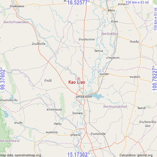
Kao Liao GPS coordinates[2]
15° 51' 1.908" North, 100° 4' 44.904" East
| Map corner | latitude | longitude |
|---|---|---|
| Upper-left | 16.52577°, | 99.37602° |
| Center: | 15.85053°, | 100.07914° |
| Lower-right: | 15.17302°, | 100.78227° |
| Map W x H: | 150.4×150.4 km | = 93.5×93.5mi |
| max Lat: | 20.43353° ⇑36.3% North |
| Kao Liao: | 15.85053° |
| min Lat: | ⇓63.7% South 5.77434° |
| min Long | Kao Liao | max Long |
| 97.93288° | 100.07914° | 105.49506° |
| W 29.8%⇐ | ⇒70.2% E |
Elevation
Elevation of Kao Liao is 36 m = 118 ft, and this is 89.5 m = 294 ft below average elevation for this country.
| Max E: |
1011 m = 3317 ft | 63.3% |
| Avg. | 125.5 m = 412 ft | |
| Kao Liao | 36 m = 118 ft | |
Min E: |
1 m = 3 ft | 36.7% |
See also: Thailand elevation on elevation.city.
Geographical zone
Kao Liao is located in North Torrid zone (between Equator and Tropic of Cancer). Distance of this Northern Tropic circle is 843.5 km =524.1 mi to North.| Distance of | km | miles | from Kao Liao |
|---|---|---|---|
| North Pole | 8244.6 | 5123 | to North |
| Arctic Circle | 5638.8 | 3503.8 | to North |
| Tropic Cancer | 843.5 | 524.1 | to North |
| Equator | 1762.4 | 1095.1 | to South |


Nearby cities:
15 places around Kao Liao: (largest is in red/bold)
• Bang Mun Nak
37.7 km =23.4 mi,  58°
58°
• Banphot Phisai
14.1 km =8.8 mi,  312°
312°
• Bueng Na Rang
36 km =22.4 mi,  7°
7°
• Bueng Samakkhi
39.1 km =24.3 mi,  343°
343°
• Chumsaeng
24.9 km =15.5 mi,  79°
79°
• Khanu Woralaksaburi
33.1 km =20.6 mi,  315°
315°
• Krok Phra
32.8 km =20.4 mi,  181°
181°
• Lat Yao
32.9 km =20.4 mi,  250°
250°
• Nakhon Sawan
17.4 km =10.8 mi,  159°
159°
• Phayuha Khiri
44.4 km =27.6 mi,  172°
172°
• Pho Thale
33.2 km =20.6 mi,  35°
35°
• Sawang Arom
37.7 km =23.4 mi,  218°
218°
• Tha Tako
48.6 km =30.2 mi,  118°
118°
• Thap Than
47.8 km =29.7 mi,  204°
204°
• Uthai Thani
52.7 km =32.7 mi,  186°
186°
Sources, notices
• [Note1] Compared only with cities in Thailand existing in our database
• [Src1] Map data: © OpenStreetMap contributors (CC-BY-SA)
• [Src2] Other city data from geonames.org with taken over terms of usage.
• [Src3] Geographical zone / Annual Mean Temperature by Robert A. Rohde @ Wikipedia
