Banphot Phisai geodata
Banphot Phisai (Nakhon Sawan) is a seat of a second-order administrative division; located in Thailand in Asia/Bangkok (GMT+7) time zone. In our database, there are 331 cities with bigger population. Compared to other cities in Thailand, 64.6% of cities are located further ↓South; 73% of cities are located further →East and 59.6% of cities have higher elevation than Banphot Phisai. Note1


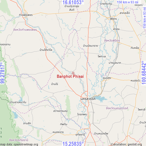
Banphot Phisai GPS coordinates[2]
15° 56' 8.088" North, 99° 58' 52.644" East
| Map corner | latitude | longitude |
|---|---|---|
| Upper-left | 16.61053°, | 99.27817° |
| Center: | 15.93558°, | 99.98129° |
| Lower-right: | 15.25835°, | 100.68442° |
| Map W x H: | 150.3×150.4 km | = 93.4×93.5mi |
| max Lat: | 20.43353° ⇑35.4% North |
| Banphot Phisai: | 15.93558° |
| min Lat: | ⇓64.6% South 5.77434° |
| min Long | Banphot Phisai | max Long |
| 97.93288° | 99.98129° | 105.49506° |
| W 27%⇐ | ⇒73% E |
Elevation
Elevation of Banphot Phisai is 46 m = 151 ft, and this is 79.5 m = 261 ft below average elevation for this country.
| Max E: |
1011 m = 3317 ft | 59.6% |
| Avg. | 125.5 m = 412 ft | |
| Banphot Phisai | 46 m = 151 ft | |
Min E: |
1 m = 3 ft | 40.4% |
See also: Thailand elevation on elevation.city.
Geographical zone
Banphot Phisai is located in North Torrid zone (between Equator and Tropic of Cancer). Distance of this Northern Tropic circle is 834 km =518.2 mi to North.| Distance of | km | miles | from Banphot Phisai |
|---|---|---|---|
| North Pole | 8235.2 | 5117.1 | to North |
| Arctic Circle | 5629.3 | 3497.9 | to North |
| Tropic Cancer | 834 | 518.2 | to North |
| Equator | 1771.9 | 1101 | to South |


Nearby cities:
15 places around Banphot Phisai: (largest is in red/bold)
• Bang Mun Nak
43.7 km =27.2 mi,  76°
76°
• Bueng Na Rang
30.4 km =18.9 mi,  30°
30°
• Bueng Samakkhi
28 km =17.4 mi,  358°
358°
• Chumsaeng
35.3 km =21.9 mi,  97°
97°
• Kao Liao
14.1 km =8.8 mi,  132°
132°
• Khanu Woralaksaburi
19.1 km =11.9 mi,  317°
317°
• Khlong Khlung
41.9 km =26 mi, 318°
• Krok Phra
43.3 km =26.9 mi,  167°
167°
• Lat Yao
29 km =18 mi,  225°
225°
• Mae Wong
52.4 km =32.6 mi,  250°
250°
• Nakhon Sawan
30.6 km =19 mi,  146°
146°
• Pho Thale
34.6 km =21.5 mi,  59°
59°
• Sawang Arom
41.2 km =25.6 mi,  198°
198°
• Thap Than
53.7 km =33.4 mi,  190°
190°
• Thung Sai
45.1 km =28 mi,  339°
339°
Sources, notices
• [Note1] Compared only with cities in Thailand existing in our database
• [Src1] Map data: © OpenStreetMap contributors (CC-BY-SA)
• [Src2] Other city data from geonames.org with taken over terms of usage.
• [Src3] Geographical zone / Annual Mean Temperature by Robert A. Rohde @ Wikipedia
