Bang Rachan geodata
Bang Rachan (Sing Buri) is a seat of a second-order administrative division; located in Thailand in Asia/Bangkok (GMT+7) time zone. In our database, there are 331 cities with bigger population. Compared to other cities in Thailand, 53.1% of cities are located further ↑North; 64.7% of cities are located further →East and 80.8% of cities have higher elevation than Bang Rachan. Note1


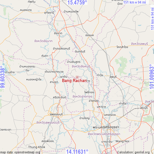
Bang Rachan GPS coordinates[2]
14° 47' 49.812" North, 100° 18' 23.4" East
| Map corner | latitude | longitude |
|---|---|---|
| Upper-left | 15.4759°, | 99.60338° |
| Center: | 14.79717°, | 100.3065° |
| Lower-right: | 14.11631°, | 101.00963° |
| Map W x H: | 151.2×151.2 km | = 94×94mi |
| max Lat: | 20.43353° ⇑53.1% North |
| Bang Rachan: | 14.79717° |
| min Lat: | ⇓46.9% South 5.77434° |
| min Long | Bang Rachan | max Long |
| 97.93288° | 100.3065° | 105.49506° |
| W 35.3%⇐ | ⇒64.7% E |
Elevation
Elevation of Bang Rachan is 12 m = 39 ft, and this is 113.5 m = 372 ft below average elevation for this country.
| Max E: |
1011 m = 3317 ft | 80.8% |
| Avg. | 125.5 m = 412 ft | |
| Bang Rachan | 12 m = 39 ft | |
Min E: |
1 m = 3 ft | 19.2% |
See also: Thailand elevation on elevation.city.
Geographical zone
Bang Rachan is located in North Torrid zone (between Equator and Tropic of Cancer). Distance of this Northern Tropic circle is 960.6 km =596.9 mi to North.| Distance of | km | miles | from Bang Rachan |
|---|---|---|---|
| North Pole | 8361.8 | 5195.8 | to North |
| Arctic Circle | 5755.9 | 3576.5 | to North |
| Tropic Cancer | 960.6 | 596.9 | to North |
| Equator | 1645.3 | 1022.3 | to South |


Nearby cities:
15 places around Bang Rachan: (largest is in red/bold)
• Ban Sam Chuk
23.5 km =14.6 mi,  254°
254°
• Bang Racham
10.6 km =6.6 mi,  6°
6°
• Chaiyo
22 km =13.7 mi,  127°
127°
• Doem Bang Nang Buat
23.3 km =14.5 mi,  285°
285°
• Doembang Nangbuat
22.6 km =14 mi,  280°
280°
• In Buri
23.5 km =14.6 mi, 5°
• Pho Thong
18.2 km =11.3 mi,  142°
142°
• Phrom Buri
15.8 km =9.8 mi,  92°
92°
• Sam Ko
23.1 km =14.4 mi,  204°
204°
• Sawaeng Ha
6.2 km =3.9 mi,  156°
156°
• Sawaengha
5.4 km =3.4 mi, 158°
• Sing Buri
14.6 km =9.1 mi,  46°
46°
• Tha Chang
9.8 km =6.1 mi,  113°
113°
• Tha Wung
21.2 km =13.2 mi, 85°
• Wiset Chaichan
22.8 km =14.2 mi,  171°
171°
Sources, notices
• [Note1] Compared only with cities in Thailand existing in our database
• [Src1] Map data: © OpenStreetMap contributors (CC-BY-SA)
• [Src2] Other city data from geonames.org with taken over terms of usage.
• [Src3] Geographical zone / Annual Mean Temperature by Robert A. Rohde @ Wikipedia
