Chatturat geodata
Chatturat (Chaiyaphum) is a seat of a second-order administrative division; located in Thailand in Asia/Bangkok (GMT+7) time zone. In our database, there are 331 cities with bigger population. Compared to other cities in Thailand, 59.2% of cities are located further ↓South; 65% of cities are located further ←West and 79.7% of cities have lower elevation than Chatturat. Note1


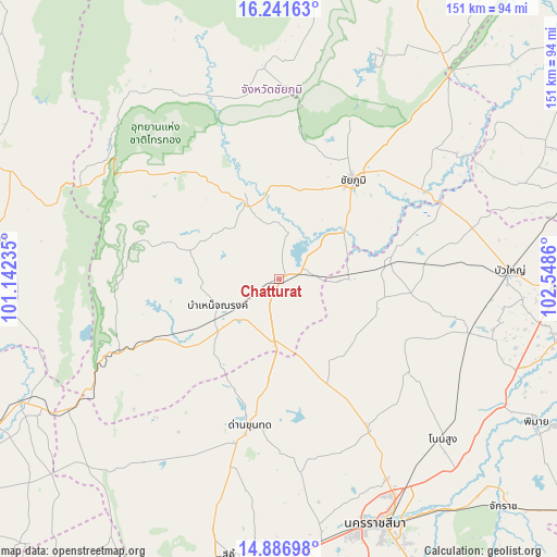
Chatturat GPS coordinates[2]
15° 33' 55.512" North, 101° 50' 43.692" East
| Map corner | latitude | longitude |
|---|---|---|
| Upper-left | 16.24163°, | 101.14235° |
| Center: | 15.56542°, | 101.84547° |
| Lower-right: | 14.88698°, | 102.5486° |
| Map W x H: | 150.6×150.6 km | = 93.6×93.6mi |
| max Lat: | 20.43353° ⇑40.8% North |
| Chatturat: | 15.56542° |
| min Lat: | ⇓59.2% South 5.77434° |
| min Long | Chatturat | max Long |
| 97.93288° | 101.84547° | 105.49506° |
| W 65%⇐ | ⇒35% E |
Elevation
Elevation of Chatturat is 196 m = 643 ft, and this is 70.5 m = 231 ft above average elevation for this country.
| Max E: |
1011 m = 3317 ft | 20.3% |
| Chatturat | 196 m 643 ft | |
| Avg. | 125.5 m = 412 ft | |
Min E: |
1 m = 3 ft | 79.7% |
See also: Thailand elevation on elevation.city.
Geographical zone
Chatturat is located in North Torrid zone (between Equator and Tropic of Cancer). Distance of this Northern Tropic circle is 875.2 km =543.8 mi to North.| Distance of | km | miles | from Chatturat |
|---|---|---|---|
| North Pole | 8276.3 | 5142.7 | to North |
| Arctic Circle | 5670.5 | 3523.5 | to North |
| Tropic Cancer | 875.2 | 543.8 | to North |
| Equator | 1730.7 | 1075.4 | to South |


Nearby cities:
15 places around Chatturat: (largest is in red/bold)
• Bamnet Narong
18.1 km =11.2 mi,  247°
247°
• Ban Khwao
24.5 km =15.2 mi,  15°
15°
• Ban Lueam
30.8 km =19.1 mi,  80°
80°
• Chaiyaphum
33.6 km =20.9 mi,  35°
35°
• Dan Khun Thot
40.5 km =25.2 mi,  191°
191°
• Kaeng Sanam Nang
48.4 km =30.1 mi,  64°
64°
• Kham Sakae Saeng
43.6 km =27.1 mi,  126°
126°
• Khong
53.5 km =33.2 mi,  104°
104°
• Noen Sa-nga
16.7 km =10.4 mi,  90°
90°
• Non Thai
47.7 km =29.6 mi,  149°
149°
• Nong Bua Rawe
22.6 km =14 mi,  337°
337°
• Phra Thong Kham
38.1 km =23.7 mi, 150°
• Sap Yai
25.8 km =16 mi,  288°
288°
• Thep Sathit
46.5 km =28.9 mi, 245°
• Thepharak
42.6 km =26.5 mi,  227°
227°
Sources, notices
• [Note1] Compared only with cities in Thailand existing in our database
• [Src1] Map data: © OpenStreetMap contributors (CC-BY-SA)
• [Src2] Other city data from geonames.org with taken over terms of usage.
• [Src3] Geographical zone / Annual Mean Temperature by Robert A. Rohde @ Wikipedia
