Ban Sam Chuk geodata
Ban Sam Chuk (Suphan Buri) is a populated place; located in Thailand in Asia/Bangkok (GMT+7) time zone. With population of 13,438 people, there are 246 cities with bigger population in this country. Compared to other cities in Thailand, 54.7% of cities are located further ↑North; 69.6% of cities are located further →East and 78.4% of cities have higher elevation than Ban Sam Chuk. Note1


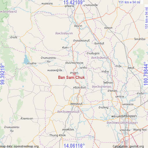
Ban Sam Chuk GPS coordinates[2]
14° 44' 31.884" North, 100° 5' 43.116" East
| Map corner | latitude | longitude |
|---|---|---|
| Upper-left | 15.42109°, | 99.39219° |
| Center: | 14.74219°, | 100.09531° |
| Lower-right: | 14.06116°, | 100.79844° |
| Map W x H: | 151.2×151.2 km | = 94×94mi |
| max Lat: | 20.43353° ⇑54.7% North |
| Ban Sam Chuk: | 14.74219° |
| min Lat: | ⇓45.3% South 5.77434° |
| min Long | Ban Sam Chuk | max Long |
| 97.93288° | 100.09531° | 105.49506° |
| W 30.4%⇐ | ⇒69.6% E |
Elevation
Elevation of Ban Sam Chuk is 13 m = 43 ft, and this is 112.5 m = 369 ft below average elevation for this country.
| Max E: |
1011 m = 3317 ft | 78.4% |
| Avg. | 125.5 m = 412 ft | |
| Ban Sam Chuk | 13 m = 43 ft | |
Min E: |
1 m = 3 ft | 21.6% |
See also: Thailand elevation on elevation.city.
Geographical zone
Ban Sam Chuk is located in North Torrid zone (between Equator and Tropic of Cancer). Distance of this Northern Tropic circle is 966.7 km =600.7 mi to North.| Distance of | km | miles | from Ban Sam Chuk |
|---|---|---|---|
| North Pole | 8367.9 | 5199.6 | to North |
| Arctic Circle | 5762 | 3580.3 | to North |
| Tropic Cancer | 966.7 | 600.7 | to North |
| Equator | 1639.2 | 1018.6 | to South |


Nearby cities:
15 places around Ban Sam Chuk: (largest is in red/bold)
• Bang Racham
29.1 km =18.1 mi,  55°
55°
• Bang Rachan
23.5 km =14.6 mi,  74°
74°
• Doem Bang Nang Buat
12.5 km =7.8 mi,  1°
1°
• Doembang Nangbuat
10.1 km =6.3 mi, 2°
• Don Chedi
14.4 km =8.9 mi,  213°
213°
• Hankha
28 km =17.4 mi,  341°
341°
• Noen Kham
28.6 km =17.8 mi,  323°
323°
• Nong Yasai
20.3 km =12.6 mi,  281°
281°
• Sam Chuk
1.8 km =1.1 mi, 341°
• Sam Ko
20 km =12.4 mi,  138°
138°
• Sawaeng Ha
25.2 km =15.7 mi,  88°
88°
• Sawaengha
24.7 km =15.3 mi, 87°
• Si Prachan
14.6 km =9.1 mi,  158°
158°
• Suphan Buri
29.9 km =18.6 mi,  174°
174°
• Wiset Chaichan
30.9 km =19.2 mi,  122°
122°
Sources, notices
• [Note1] Compared only with cities in Thailand existing in our database
• [Src1] Map data: © OpenStreetMap contributors (CC-BY-SA)
• [Src2] Other city data from geonames.org with taken over terms of usage.
• [Src3] Geographical zone / Annual Mean Temperature by Robert A. Rohde @ Wikipedia
