Don Chedi geodata
Don Chedi (Suphan Buri) is a seat of a second-order administrative division; located in Thailand in Asia/Bangkok (GMT+7) time zone. In our database, there are 331 cities with bigger population. Compared to other cities in Thailand, 56.8% of cities are located further ↑North; 71.9% of cities are located further →East and 75.3% of cities have higher elevation than Don Chedi. Note1


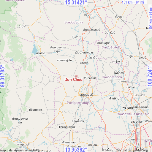
Don Chedi GPS coordinates[2]
14° 38' 5.892" North, 100° 1' 15.492" East
| Map corner | latitude | longitude |
|---|---|---|
| Upper-left | 15.31421°, | 99.31785° |
| Center: | 14.63497°, | 100.02097° |
| Lower-right: | 13.95362°, | 100.7241° |
| Map W x H: | 151.3×151.3 km | = 94×94mi |
| max Lat: | 20.43353° ⇑56.8% North |
| Don Chedi: | 14.63497° |
| min Lat: | ⇓43.2% South 5.77434° |
| min Long | Don Chedi | max Long |
| 97.93288° | 100.02097° | 105.49506° |
| W 28.1%⇐ | ⇒71.9% E |
Elevation
Elevation of Don Chedi is 15 m = 49 ft, and this is 110.5 m = 363 ft below average elevation for this country.
| Max E: |
1011 m = 3317 ft | 75.3% |
| Avg. | 125.5 m = 412 ft | |
| Don Chedi | 15 m = 49 ft | |
Min E: |
1 m = 3 ft | 24.7% |
See also: Thailand elevation on elevation.city.
Geographical zone
Don Chedi is located in North Torrid zone (between Equator and Tropic of Cancer). Distance of this Northern Tropic circle is 978.7 km =608.1 mi to North.| Distance of | km | miles | from Don Chedi |
|---|---|---|---|
| North Pole | 8379.8 | 5207 | to North |
| Arctic Circle | 5773.9 | 3587.7 | to North |
| Tropic Cancer | 978.7 | 608.1 | to North |
| Equator | 1627.3 | 1011.2 | to South |


Nearby cities:
15 places around Don Chedi: (largest is in red/bold)
• Ban Sam Chuk
14.4 km =8.9 mi,  33°
33°
• Bang Pla Ma
30.4 km =18.9 mi,  150°
150°
• Bang Rachan
35.6 km =22.1 mi,  59°
59°
• Doem Bang Nang Buat
25.7 km =16 mi,  18°
18°
• Doembang Nangbuat
23.6 km =14.7 mi, 21°
• Lao Khwan
26.9 km =16.7 mi,  260°
260°
• Nong Yasai
20 km =12.4 mi,  323°
323°
• Sam Chuk
15.5 km =9.6 mi, 28°
• Sam Ko
21.5 km =13.4 mi,  98°
98°
• Sawaeng Ha
35.4 km =22 mi,  69°
69°
• Sawaengha
35.2 km =21.9 mi, 68°
• Si Prachan
13.4 km =8.3 mi, 97°
• Suphan Buri
20.9 km =13 mi, 148°
• U Thong
32 km =19.9 mi,  205°
205°
• Wiset Chaichan
34.4 km =21.4 mi, 97°
Sources, notices
• [Note1] Compared only with cities in Thailand existing in our database
• [Src1] Map data: © OpenStreetMap contributors (CC-BY-SA)
• [Src2] Other city data from geonames.org with taken over terms of usage.
• [Src3] Geographical zone / Annual Mean Temperature by Robert A. Rohde @ Wikipedia
