Suphan Buri geodata
Suphan Buri is a seat of a first-order administrative division; located in Thailand in Asia/Bangkok (GMT+7) time zone. With population of 53,399 people, there are 49 cities with bigger population in this country. Compared to other cities in Thailand, 59.9% of cities are located further ↑North; 68.7% of cities are located further →East and 80.8% of cities have higher elevation than Suphan Buri. Note1


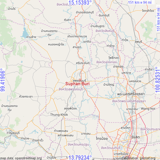
Suphan Buri GPS coordinates[2]
14° 28' 27.048" North, 100° 7' 19.848" East
| Map corner | latitude | longitude |
|---|---|---|
| Upper-left | 15.15393°, | 99.41906° |
| Center: | 14.47418°, | 100.12218° |
| Lower-right: | 13.79234°, | 100.82531° |
| Map W x H: | 151.4×151.4 km | = 94.1×94.1mi |
| max Lat: | 20.43353° ⇑59.9% North |
| Suphan Buri: | 14.47418° |
| min Lat: | ⇓40.1% South 5.77434° |
| min Long | Suphan Buri | max Long |
| 97.93288° | 100.12218° | 105.49506° |
| W 31.3%⇐ | ⇒68.7% E |
Elevation
Elevation of Suphan Buri is 12 m = 39 ft, and this is 113.5 m = 372 ft below average elevation for this country.
| Max E: |
1011 m = 3317 ft | 80.8% |
| Avg. | 125.5 m = 412 ft | |
| Suphan Buri | 12 m = 39 ft | |
Min E: |
1 m = 3 ft | 19.2% |
See also: Suphan Buri elevation on elevation.city.
Geographical zone
Suphan Buri is located in North Torrid zone (between Equator and Tropic of Cancer). Distance of this Northern Tropic circle is 996.5 km =619.2 mi to North.| Distance of | km | miles | from Suphan Buri |
|---|---|---|---|
| North Pole | 8397.7 | 5218.1 | to North |
| Arctic Circle | 5791.8 | 3598.9 | to North |
| Tropic Cancer | 996.5 | 619.2 | to North |
| Equator | 1609.4 | 1000 | to South |


Nearby cities:
15 places around Suphan Buri: (largest is in red/bold)
• Ban Sam Chuk
29.9 km =18.6 mi,  354°
354°
• Bang Pla Ma
9.5 km =5.9 mi,  155°
155°
• Bang Sai
25 km =15.5 mi,  128°
128°
• Don Chedi
20.9 km =13 mi,  328°
328°
• Pa Mok
35.2 km =21.9 mi,  87°
87°
• Phak Hai
26.7 km =16.6 mi, 94°
• Pho Thong
37.6 km =23.4 mi,  55°
55°
• Sam Chuk
31.7 km =19.7 mi, 353°
• Sam Ko
18.1 km =11.2 mi,  35°
35°
• Sawaeng Ha
37.6 km =23.4 mi, 36°
• Sena
34.5 km =21.4 mi,  118°
118°
• Si Prachan
16.4 km =10.2 mi,  8°
8°
• Song Phi Nong
29.9 km =18.6 mi,  201°
201°
• U Thong
27.1 km =16.8 mi,  246°
246°
• Wiset Chaichan
26.8 km =16.7 mi, 60°
Sources, notices
• [Note1] Compared only with cities in Thailand existing in our database
• [Src1] Map data: © OpenStreetMap contributors (CC-BY-SA)
• [Src2] Other city data from geonames.org with taken over terms of usage.
• [Src3] Geographical zone / Annual Mean Temperature by Robert A. Rohde @ Wikipedia
