Kap Choeng geodata
Kap Choeng (Surin) is a seat of a second-order administrative division; located in Thailand in Asia/Bangkok (GMT+7) time zone. In our database, there are 331 cities with bigger population. Compared to other cities in Thailand, 59.8% of cities are located further ↑North; 85.8% of cities are located further ←West and 82.5% of cities have lower elevation than Kap Choeng. Note1


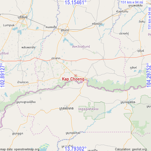
Kap Choeng GPS coordinates[2]
14° 28' 29.496" North, 103° 35' 39.804" East
| Map corner | latitude | longitude |
|---|---|---|
| Upper-left | 15.15461°, | 102.89127° |
| Center: | 14.47486°, | 103.59439° |
| Lower-right: | 13.79302°, | 104.29752° |
| Map W x H: | 151.4×151.4 km | = 94.1×94.1mi |
| max Lat: | 20.43353° ⇑59.8% North |
| Kap Choeng: | 14.47486° |
| min Lat: | ⇓40.2% South 5.77434° |
| min Long | Kap Choeng | max Long |
| 97.93288° | 103.59439° | 105.49506° |
| W 85.8%⇐ | ⇒14.2% E |
Elevation
Elevation of Kap Choeng is 207 m = 679 ft, and this is 81.5 m = 267 ft above average elevation for this country.
| Max E: |
1011 m = 3317 ft | 17.5% |
| Kap Choeng | 207 m 679 ft | |
| Avg. | 125.5 m = 412 ft | |
Min E: |
1 m = 3 ft | 82.5% |
See also: Thailand elevation on elevation.city.
Geographical zone
Kap Choeng is located in North Torrid zone (between Equator and Tropic of Cancer). Distance of this Northern Tropic circle is 996.5 km =619.2 mi to North.| Distance of | km | miles | from Kap Choeng |
|---|---|---|---|
| North Pole | 8397.6 | 5218 | to North |
| Arctic Circle | 5791.7 | 3598.8 | to North |
| Tropic Cancer | 996.5 | 619.2 | to North |
| Equator | 1609.5 | 1000.1 | to South |


Nearby cities:
15 places around Kap Choeng: (largest is in red/bold)
• Ban Kruat
53.6 km =33.3 mi,  263°
263°
• Bua Chet
38.3 km =23.8 mi,  81°
81°
• Khwao Sinarin
58.7 km =36.5 mi,  359°
359°
• Krasang
58.9 km =36.6 mi,  327°
327°
• Lamduan
28.6 km =17.8 mi,  16°
16°
• Phanom Dong Rak
31.3 km =19.4 mi, 264°
• Phlapphla Chai
54 km =33.6 mi,  301°
301°
• Phu Sing
58.4 km =36.3 mi, 82°
• Prakhon Chai
53 km =32.9 mi,  285°
285°
• Prakhon Chai
57.5 km =35.7 mi, 285°
• Prasat
27.5 km =17.1 mi,  312°
312°
• Sangkha
33.1 km =20.6 mi,  57°
57°
• Si Khoraphum
56.6 km =35.2 mi, 22°
• Si Narong
44.3 km =27.5 mi,  42°
42°
• Surin
46.5 km =28.9 mi,  346°
346°
Sources, notices
• [Note1] Compared only with cities in Thailand existing in our database
• [Src1] Map data: © OpenStreetMap contributors (CC-BY-SA)
• [Src2] Other city data from geonames.org with taken over terms of usage.
• [Src3] Geographical zone / Annual Mean Temperature by Robert A. Rohde @ Wikipedia
