Panj geodata
Panj (Khatlon) is a seat of a second-order administrative division; located in Tajikistan in Asia/Dushanbe (GMT+5) time zone. With population of 8,019 people, there are 41 cities with bigger population in this country. Compared to other cities in Tajikistan, 98.9% of cities are located further ↑North; 59.1% of cities are located further →East and 94.3% of cities have higher elevation than Panj. Note1


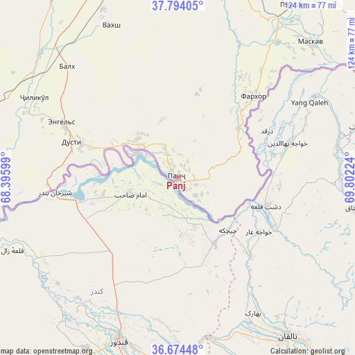
Panj GPS coordinates[2]
37° 14' 10.824" North, 69° 5' 56.796" East
| Map corner | latitude | longitude |
|---|---|---|
| Upper-left | 37.79405°, | 68.39599° |
| Center: | 37.23634°, | 69.09911° |
| Lower-right: | 36.67448°, | 69.80224° |
| Map W x H: | 124.5×124.5 km | = 77.4×77.4mi |
| max Lat: | 40.99827° ⇑98.9% North |
| Panj: | 37.23634° |
| min Lat: | ⇓1.1% South 36.72484° |
| min Long | Panj | max Long |
| 67.60931° | 69.09911° | 73.96674° |
| W 40.9%⇐ | ⇒59.1% E |
Elevation
Elevation of Panj is 368 m = 1207 ft, and this is 594.5 m = 1950 ft below average elevation for this country.
| Max E: |
3607 m = 11834 ft | 94.3% |
| Avg. | 962.5 m = 3158 ft | |
| Panj | 368 m = 1207 ft | |
Min E: |
324 m = 1063 ft | 5.7% |
See also: Tajikistan elevation on elevation.city.
Geographical zone
Panj is located in North temperate zone (between Tropic of Cancer and the Arctic Circle). Distance of this Northern Tropic circle is 1534.4 km =953.4 mi to South.| Distance of | km | miles | from Panj |
|---|---|---|---|
| North Pole | 5866.8 | 3645.5 | to North |
| Arctic Circle | 3260.9 | 2026.2 | to North |
| Tropic Cancer | 1534.4 | 953.4 | to South |
| Equator | 4140.3 | 2572.7 | to South |


Nearby cities:
15 places around Panj: (largest is in red/bold)
• Bŭstonqal’a
72 km =44.7 mi,  340°
340°
• Chubek
68.1 km =42.3 mi,  51°
51°
• Dŭstí
40.4 km =25.1 mi,  287°
287°
• Farkhor
39.2 km =24.4 mi,  43°
43°
• Gharavŭtí
68.4 km =42.5 mi,  302°
302°
• Ismoili Somoní
64.5 km =40.1 mi, 335°
• Jilikŭl
57.7 km =35.9 mi, 299°
• Kirov
68.2 km =42.4 mi, 341°
• Kolkhozobod
55.2 km =34.3 mi,  315°
315°
• Moskovskiy
61.8 km =38.4 mi,  312°
312°
• Moskva
66.4 km =41.3 mi, 44°
• Orzu
43.5 km =27 mi,  325°
325°
• Qŭrghonteppa
72.1 km =44.8 mi, 337°
• Sarband
72.3 km =44.9 mi,  347°
347°
• Vakhsh
58.1 km =36.1 mi, 336°
Sources, notices
• [Note1] Compared only with cities in Tajikistan existing in our database
• [Src1] Map data: © OpenStreetMap contributors (CC-BY-SA)
• [Src2] Other city data from geonames.org with taken over terms of usage.
• [Src3] Geographical zone / Annual Mean Temperature by Robert A. Rohde @ Wikipedia
