Chubek geodata
Chubek (Khatlon) is a populated place; located in Tajikistan in Asia/Dushanbe (GMT+5) time zone. With population of 19,563 people, there are 19 cities with bigger population in this country. Compared to other cities in Tajikistan, 81.8% of cities are located further ↑North; 63.6% of cities are located further ←West and 62.5% of cities have higher elevation than Chubek. Note1


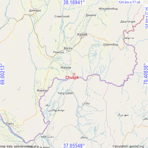
Chubek GPS coordinates[2]
37° 36' 52.308" North, 69° 42' 18.9" East
| Map corner | latitude | longitude |
|---|---|---|
| Upper-left | 38.16941°, | 69.00213° |
| Center: | 37.61453°, | 69.70525° |
| Lower-right: | 37.05548°, | 70.40838° |
| Map W x H: | 123.9×123.9 km | = 77×77mi |
| max Lat: | 40.99827° ⇑81.8% North |
| Chubek: | 37.61453° |
| min Lat: | ⇓18.2% South 36.72484° |
| min Long | Chubek | max Long |
| 67.60931° | 69.70525° | 73.96674° |
| W 63.6%⇐ | ⇒36.4% E |
Elevation
Elevation of Chubek is 514 m = 1686 ft, and this is 448.5 m = 1471 ft below average elevation for this country.
| Max E: |
3607 m = 11834 ft | 62.5% |
| Avg. | 962.5 m = 3158 ft | |
| Chubek | 514 m = 1686 ft | |
Min E: |
324 m = 1063 ft | 37.5% |
See also: Tajikistan elevation on elevation.city.
Geographical zone
Chubek is located in North temperate zone (between Tropic of Cancer and the Arctic Circle). Distance of this Northern Tropic circle is 1576.4 km =979.5 mi to South.| Distance of | km | miles | from Chubek |
|---|---|---|---|
| North Pole | 5824.7 | 3619.3 | to North |
| Arctic Circle | 3218.8 | 2000.1 | to North |
| Tropic Cancer | 1576.4 | 979.5 | to South |
| Equator | 4182.3 | 2598.8 | to South |


Nearby cities:
15 places around Chubek: (largest is in red/bold)
• Baljuvon
77.2 km =48 mi,  358°
358°
• Bŭstonqal’a
81.1 km =50.4 mi,  288°
288°
• Danghara
62.4 km =38.8 mi,  329°
329°
• Farkhor
29.9 km =18.6 mi,  242°
242°
• Kirov
77.8 km =48.3 mi, 286°
• Kŭlob
34.1 km =21.2 mi,  11°
11°
• Moskva
8.5 km =5.3 mi,  307°
307°
• Mŭ’minobod
61.8 km =38.4 mi,  27°
27°
• Orzu
78.3 km =48.7 mi,  265°
265°
• Panj
68.1 km =42.3 mi,  231°
231°
• Sarband
74.5 km =46.3 mi, 292°
• Shŭrobod
39.3 km =24.4 mi,  50°
50°
• Sovet
49.1 km =30.5 mi,  347°
347°
• Vakhsh
77.4 km =48.1 mi,  278°
278°
• Vose’
21.7 km =13.5 mi, 345°
Sources, notices
• [Note1] Compared only with cities in Tajikistan existing in our database
• [Src1] Map data: © OpenStreetMap contributors (CC-BY-SA)
• [Src2] Other city data from geonames.org with taken over terms of usage.
• [Src3] Geographical zone / Annual Mean Temperature by Robert A. Rohde @ Wikipedia
