Zaghouan geodata
Zaghouan (Zaghwān) is a seat of a first-order administrative division; located in Tunisia in Africa/Tunis (GMT+1) time zone. With population of 16,911 people, there are 64 cities with bigger population in this country. Compared to other cities in Tunisia, 63.6% of cities are located further ↓South; 52.4% of cities are located further →East and 74.8% of cities have lower elevation than Zaghouan. Note1


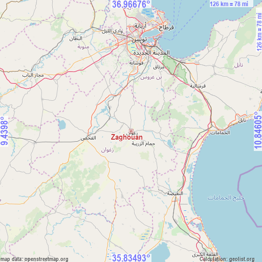
Zaghouan GPS coordinates[2]
36° 24' 10.476" North, 10° 8' 34.512" East
| Map corner | latitude | longitude |
|---|---|---|
| Upper-left | 36.96676°, | 9.4398° |
| Center: | 36.40291°, | 10.14292° |
| Lower-right: | 35.83493°, | 10.84605° |
| Map W x H: | 125.8×125.8 km | = 78.2×78.2mi |
| max Lat: | 37.27442° ⇑36.4% North |
| Zaghouan: | 36.40291° |
| min Lat: | ⇓63.6% South 32.31662° |
| min Long | Zaghouan | max Long |
| 7.87765° | 10.14292° | 11.21965° |
| W 47.6%⇐ | ⇒52.4% E |
Elevation
Elevation of Zaghouan is 176 m = 577 ft, and this is 26.6 m = 87 ft above average elevation for this country.
| Max E: |
999 m = 3278 ft | 25.2% |
| Zaghouan | 176 m 577 ft | |
| Avg. | 149.4 m = 490 ft | |
Min E: |
-6 m = -20 ft | 74.8% |
See also: Tunisia elevation on elevation.city.
Geographical zone
Zaghouan is located in North temperate zone (between Tropic of Cancer and the Arctic Circle). Distance of this Northern Tropic circle is 1441.7 km =895.8 mi to South.| Distance of | km | miles | from Zaghouan |
|---|---|---|---|
| North Pole | 5959.4 | 3703 | to North |
| Arctic Circle | 3353.5 | 2083.8 | to North |
| Tropic Cancer | 1441.7 | 895.8 | to South |
| Equator | 4047.6 | 2515.1 | to South |


Nearby cities:
15 places around Zaghouan: (largest is in red/bold)
• Ben Arous
39.7 km =24.7 mi,  10°
10°
• Beni Khalled
48.5 km =30.1 mi,  55°
55°
• Bou Arada
47 km =29.2 mi,  263°
263°
• Bou Arkoub
39.5 km =24.5 mi,  67°
67°
• El Fahs
21.4 km =13.3 mi, 261°
• Goubellat
45.6 km =28.3 mi,  289°
289°
• Hammam-Lif
40.3 km =25 mi,  26°
26°
• Hammamet
42.4 km =26.3 mi,  90°
90°
• La Goulette
48.4 km =30.1 mi,  17°
17°
• La Mohammedia
30.2 km =18.8 mi,  2°
2°
• La Sebala du Mornag
33.5 km =20.8 mi, 23°
• Manouba
45.5 km =28.3 mi,  354°
354°
• Radès
42.4 km =26.3 mi, 16°
• Tunis
46.3 km =28.8 mi, 2°
• Zaouiat Djedidi
46.9 km =29.1 mi, 55°
Sources, notices
• [Note1] Compared only with cities in Tunisia existing in our database
• [Src1] Map data: © OpenStreetMap contributors (CC-BY-SA)
• [Src2] Other city data from geonames.org with taken over terms of usage.
• [Src3] Geographical zone / Annual Mean Temperature by Robert A. Rohde @ Wikipedia
