Goubellat geodata
Goubellat (Bājah) is a populated place; located in Tunisia in Africa/Tunis (GMT+1) time zone. With population of 3,353 people, there are 134 cities with bigger population in this country. Compared to other cities in Tunisia, 70.6% of cities are located further ↓South; 70.6% of cities are located further →East and 71.3% of cities have lower elevation than Goubellat. Note1


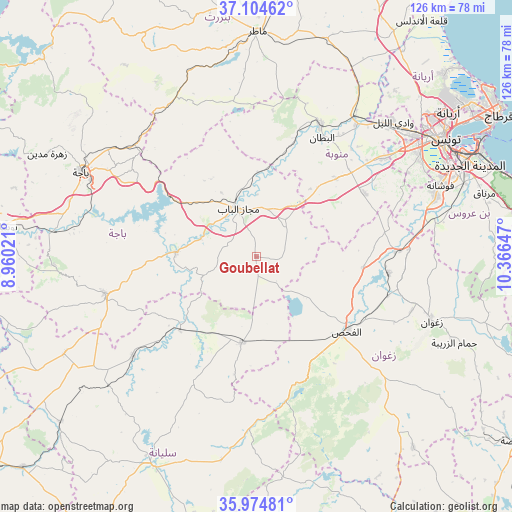
Goubellat GPS coordinates[2]
36° 32' 30.408" North, 9° 39' 48.024" East
| Map corner | latitude | longitude |
|---|---|---|
| Upper-left | 37.10462°, | 8.96021° |
| Center: | 36.54178°, | 9.66334° |
| Lower-right: | 35.97481°, | 10.36647° |
| Map W x H: | 125.6×125.6 km | = 78×78mi |
| max Lat: | 37.27442° ⇑29.4% North |
| Goubellat: | 36.54178° |
| min Lat: | ⇓70.6% South 32.31662° |
| min Long | Goubellat | max Long |
| 7.87765° | 9.66334° | 11.21965° |
| W 29.4%⇐ | ⇒70.6% E |
Elevation
Elevation of Goubellat is 138 m = 453 ft, and this is 11.4 m = 37 ft below average elevation for this country.
| Max E: |
999 m = 3278 ft | 28.7% |
| Avg. | 149.4 m = 490 ft | |
| Goubellat | 138 m = 453 ft | |
Min E: |
-6 m = -20 ft | 71.3% |
See also: Tunisia elevation on elevation.city.
Geographical zone
Goubellat is located in North temperate zone (between Tropic of Cancer and the Arctic Circle). Distance of this Northern Tropic circle is 1457.1 km =905.4 mi to South.| Distance of | km | miles | from Goubellat |
|---|---|---|---|
| North Pole | 5944 | 3693.4 | to North |
| Arctic Circle | 3338.1 | 2074.2 | to North |
| Tropic Cancer | 1457.1 | 905.4 | to South |
| Equator | 4063.1 | 2524.7 | to South |


Nearby cities:
15 places around Goubellat: (largest is in red/bold)
• Ben Arous
55.1 km =34.2 mi,  64°
64°
• Bou Arada
21.4 km =13.3 mi,  190°
190°
• Béja
47.6 km =29.6 mi,  295°
295°
• El Battan
33.3 km =20.7 mi,  28°
28°
• El Fahs
28.6 km =17.8 mi,  130°
130°
• Gafour
39.1 km =24.3 mi,  230°
230°
• La Mohammedia
46.4 km =28.8 mi,  71°
71°
• Le Krib
52.8 km =32.8 mi,  243°
243°
• Manouba
48.7 km =30.3 mi,  52°
52°
• Medjez el Bab
12.8 km =8 mi,  339°
339°
• Oued Lill
46.8 km =29.1 mi, 45°
• Tabursuq
38.3 km =23.8 mi,  255°
255°
• Testour
19.7 km =12.2 mi,  273°
273°
• Tunis
54.4 km =33.8 mi, 55°
• Zaghouan
45.6 km =28.3 mi,  109°
109°
Sources, notices
• [Note1] Compared only with cities in Tunisia existing in our database
• [Src1] Map data: © OpenStreetMap contributors (CC-BY-SA)
• [Src2] Other city data from geonames.org with taken over terms of usage.
• [Src3] Geographical zone / Annual Mean Temperature by Robert A. Rohde @ Wikipedia
