Sousse geodata
Sousse (Sūsah) is a seat of a first-order administrative division; located in Tunisia in Africa/Tunis (GMT+1) time zone. With population of 164,123 people, there are 2 cities with bigger population in this country. Compared to other cities in Tunisia, 51% of cities are located further ↑North; 70.6% of cities are located further ←West and 65.7% of cities have higher elevation than Sousse. Note1


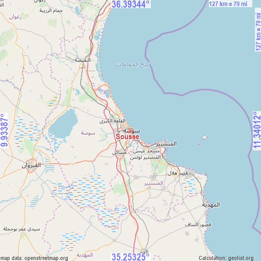
Sousse GPS coordinates[2]
35° 49' 31.404" North, 10° 38' 13.164" East
| Map corner | latitude | longitude |
|---|---|---|
| Upper-left | 36.39344°, | 9.93387° |
| Center: | 35.82539°, | 10.63699° |
| Lower-right: | 35.25325°, | 11.34012° |
| Map W x H: | 126.8×126.8 km | = 78.8×78.8mi |
| max Lat: | 37.27442° ⇑51% North |
| Sousse: | 35.82539° |
| min Lat: | ⇓49% South 32.31662° |
| min Long | Sousse | max Long |
| 7.87765° | 10.63699° | 11.21965° |
| W 70.6%⇐ | ⇒29.4% E |
Elevation
Elevation of Sousse is 24 m = 79 ft, and this is 125.4 m = 411 ft below average elevation for this country.
| Max E: |
999 m = 3278 ft | 65.7% |
| Avg. | 149.4 m = 490 ft | |
| Sousse | 24 m = 79 ft | |
Min E: |
-6 m = -20 ft | 34.3% |
See also: Sousse elevation on elevation.city.
Geographical zone
Sousse is located in North temperate zone (between Tropic of Cancer and the Arctic Circle). Distance of this Northern Tropic circle is 1377.5 km =855.9 mi to South.| Distance of | km | miles | from Sousse |
|---|---|---|---|
| North Pole | 6023.7 | 3743 | to North |
| Arctic Circle | 3417.8 | 2123.7 | to North |
| Tropic Cancer | 1377.5 | 855.9 | to South |
| Equator | 3983.4 | 2475.2 | to South |


Nearby cities:
15 places around Sousse: (largest is in red/bold)
• Akouda
8.1 km =5 mi,  306°
306°
• Banbalah
20.3 km =12.6 mi,  133°
133°
• Djemmal
25 km =15.5 mi,  154°
154°
• Hammam Sousse
5 km =3.1 mi,  322°
322°
• Harqalah
25.5 km =15.8 mi,  333°
333°
• Ksibet el Mediouni
24.2 km =15 mi, 129°
• Menzel Kamel
22.5 km =14 mi,  173°
173°
• Mesdour
17.9 km =11.1 mi, 152°
• Monastir
17.9 km =11.1 mi,  107°
107°
• Msaken
11.8 km =7.3 mi,  205°
205°
• Ouardenine
13.3 km =8.3 mi, 165°
• Port el Kantaoui
8.4 km =5.2 mi, 332°
• Sahline
10.6 km =6.6 mi,  140°
140°
• Sidi Bou Ali
20.8 km =12.9 mi, 314°
• Skanes
15.4 km =9.6 mi, 107°
Sources, notices
• [Note1] Compared only with cities in Tunisia existing in our database
• [Src1] Map data: © OpenStreetMap contributors (CC-BY-SA)
• [Src2] Other city data from geonames.org with taken over terms of usage.
• [Src3] Geographical zone / Annual Mean Temperature by Robert A. Rohde @ Wikipedia
